CORPScamp Santa Monica


As many of you know I am sidelined with a broken femur.  You can read about it here.  I had a huge season of climbing planned for 2014.  There is no time to morn for what could have been this season!  NO!  Instead of riding I will support great events that I truly believe in.  I and the REV Cycling organization endorse the AdventureCORPS events.

One such event is currently accepting camp participants.  CORPScamp Santa Monica will be held Feb 24-27 (Monday-Thursday).  Here is a description from the AdventureCORPS site:

“The latest, greatest edition of CORPScamp features four days of SAG-supported, one-of-a-kind cycling in and around the Santa Monica Mountains. We’ve been cycling regularly here since 1994 and we never tire of sharing one of the world’s most dramatic, inspiring, and invigorating landscapes.

CORPScamp Santa Monica Mountains features a specific route each day, with route sheets, support vehicle on the course, and two or more ride leaders. Most routes feature various distance options, too. Each afternoon at CORPScamp features “The Yoga Social” with a rejuvenating yoga class taught by your co-host, a fellow cyclist and life-long fitness professional: Laurie Kostman. CORPSyoga is designed for all camp participants, regardless of yoga background, or lack thereof, and is designed to help each camper unwind, accelerate recovery for the next day’s adventure, minimize the chance of injury, and rejuvenate and restore energy balance. Social time before and after the actual yoga class gives everyone a chance to swap stories while enjoying herbal tea. The camp also includes two group dinners. Every activity is optional, though; campers are free to “check out any time you like” if they want a break, extra rest, or private time.”

I have attended CORPScamps before and I can personally vouch for the quality of the support, route selection and general atmosphere.  This camp will include some of the best riding in the Santa Monica Mountains.  I’ve ridden many of the climbs but never with full SAG support.  The weather should be moderate.  Southern California has a had an unseasonably warm winter.  Click here is a post of the Death Valley CORPScamp.

If you can get away for a week of riding I strongly recommend you attend CORPScamp Santa Monica.  I hope to see you there.  I will be providing support during the camp.  Come up and introduce yourself.  You can begin your registration process here


Mt Whitney Super Century– SPOT Link


Tomorrow I will be riding the Mt Whitney Super Century.  Here is the SPOT Transmitter link if you care to follow on the SPOT page.

Thank you Brad Horton for the use of the SPOT Transmitter.

http://share.findmespot.com/shared/faces/viewspots.jsp?glId=0Po3rlAvZRhphLYqLgPtFWXFqBnoazRkk


CCSD – Cycling Camps San Diego Day 4


Day 4 – 47 miles with 6,444 feet of gain

Follow me on Facebook

Follow me on Twitter

Follow me on Strava

Day 4 began with a the long climb up White Mountain after a short warm-up of four miles.  It is the last climb (climb #3) on Day 2 of Everest Challenge.  As Paul Sherwin would say, “It’s a beast of a climb”.   Generally his exaggerations are a bit much.  But in this circumstance it is more than fitting.  Here are the stats on White Mountain– 21 miles long with an average grade of 6% and an elevation gain of 6,204′.  But even as daunting as a 6K of climbing in ONE climb may sound it still doesn’t tell the whole story.  Maximum grade in the lower half is 14% while max in the upper half is 17%. There are lots of 9-12% rollers in the bottom third. The last 3 miles average 10% grade.    Now add heat!  The last time I did Everest Challenge was 2010.  It was ridiculously hot (above 96F). Unfortunately, today was no different, 96F!  This IS a beast of a climb!

After White Mountain the CCSD camp had us scheduled to do Glacier Lodge (9 miles long with an average grade of 8% and an elevation gain of 3,860′).  But I bowed out of the second climb.  I had just the right amount of fatigue, climbing endurance and heat exposure for the day.  I felt like I had had a perfect training day.  Since I hadn’t been riding very much for the last month coming to a camp and doing over 300 miles for the week (35 miles before camp) and over 30,000 feet of climbing I knew I had nothing to prove by doing one more climb.  I actually felt that one more climb in that heat would not add anymore training value to the day.  Here is where experience comes into play.  A good workout doesn’t necessarily mean total deconstruction, exhaustion and heat stroke!  Moreover, I wanted to get back home to see my son and I was still 6 hours away!

Here are two other training days where I have done the Glacier Lodge/White Mountain combo

September 10, 2010

June 26, 2010

Above Day 2 of  Everest Challenge.

White Mountain Grade Analysis 20 miles 6220 feet of gain!!

Temperature in Big Pine – launching pad for Day 2 of Everest Challenge

White Mountain Detail- Lots of grey lines (crank torque) shooting above yellow line (power) once this indicates the steep ramps and being under-geared (38×28)

Near the summit of Ancient Bristlecone or White Mountain

As you can see White Mountain ranks prominently in the California’s toughest climbs.

Most Difficult Climbs:

1) Onion Valley — DONE 6/10/10 !!
2) Horseshoe Meadows — DONE 6/10/10!!
3) White Mountain
4) Sherman Pass
5) Whitney Portal — DONE 6/10/10!!
6) Mount Baldy
7) Shirley Meadows
8) South Lake
9) Mount Palomar DONE 6/06/10!!
10) Mosquito Flat

Greatest Elevation Gained:

1) Horseshoe Meadows – 6,234 feet– DONE 6/10/10 !!
2) White Mountain – 6,204 feet
3) 190 – 6,199 feet
4) J21/245/180 – 5,750 feet
5) Mosquito Flat – 5,548 feet
6) Dantes View – 5,475 feet
7) South Lake – 5,445 feet
8) Sherman Pass – 5,316 feet
9) Emigrant Pass – 5,309 feet
10) Onion Valley – 5,169 feet DONE 6/10/10!!

Highest Elevation Attained:

1) Mosquito Flat – 10,220 feet
2) White Mountain – 10,152 feet
3) Horseshoe Meadows – 10,034 feet DONE 6/10/10!!
4) Tioga Pass – 9,945 feet DONE 7/27/12!!
5) South Lake – 9,852 feet
6) Sonora Pass – 9,624 feet
7) Kaiser Pass – 9,184 feet
8) Onion Valley – 9,163 feet — DONE 6/10/10!!
9) Lake Sabrina – 9,141 feet
10) Sherman Pass – 9,126 feet

source

One last word on CCSD – this an exceptional way to get your climb-on and training specificity.  The Everest Challenge course reconnaissance is essential for anyone wanting to have a successful attempt at completing the event.  Most people cant put their head around a climb that is 22 miles long when that is normally the distance someone would go on a recovery ride.  The event was professionally run, well SAG’d, a nightly training lecture provided, and great healthy home made food.  I strongly encourage anyone interested to visit the CCSD website a book a camp!

Two different preparations of Salmon, Couscous, Broccoli, Corn, Squash, Spinach Salad, and fresh fruit for desert!


CCSD – Cycling Camps San Diego Day 3


Day 3 – 68 miles with 8,800 feet of gain

Follow me on Facebook

Follow me on Twitter

Follow me on Strava

After getting our feet wet with some of the climbs near Mammoth and getting acclimated at altitude it was time get on with some serious climbing. After-all, the objective of the Cycling Camps San Diego (CCSD) high altitude camp is to prepare you for two major events, Everest Challenge and the Furnace Creek 508.  Let’s briefly describe these events.  Everest Challenge has 29,000 feet of climbing in a two day format.  The Furnace Creek 508 is 508 miles with 35,000 feet of climbing in a non-stop Ultra race format.

Above are the two days of Everest Challenge.

The profile for the Furnace Creek 508

Today’s ride– notice the grey line- that is crank torque and indicates steeper grades. Yellow is power.  I should probably have a larger cassette than 28T 😉

On Day 1 of Everest Challenge we climb Mosquito Flat then Pine Creek then finish off with South Lake.  In training, unless you are a glutton for punishment, there is no real need to do all three climbs in one day to feel that you are preparing yourself properly for Everest Challenge.  I have come out to Big Pine and Lone Pine on several occasions (here and here) and done just two out of the three, Pine Creek and Mosquito Flat.  The main reason is the climb to South Lake is boooooring.  It is on a main road and if you do two miles of it you have done 10 miles of it.  It’s all the same and in my opinion and not worth the trouble.

Another climbing day at altitude and another long warm-up.  I was also a still dehyrdrated from the day before.  I felt I didn’t refuel enough either.  We began our route at Tom’s Place and descended down into Rovana to begin our first climb, Pine Creek.  As you can see on the graph below Pine Creek is a good steady climb.  It progressively gets steeper but then after mile six there are a few dips which makes the last push to the top a little easier.

 From the top of Pine Creek to the summit on Mosquito Flat I took on five bottles of fuel and water- more than I have EVER taken on this climb.  By comparison, when I come out to do this climb unsupported I take three bottles.  Furthermore, on race day I make it up this climb on two bottles.

I good long climb of 21 miles where you gain almost 6,000 feet in one climb!! I felt very well supported by CCSD.  I continued to take on water and fuel and made it to the top of Mosquito Flat.  Wow what a day!!!

Mosquito Flat- Is the highest paved road in California and so tops out at 10,250 feet. It’s a good long climb of 21 miles where you gain almost 6,000 feet in one climb!! I felt very well supported by CCSD.  I continued to take on water and fuel and made it to the top of Mosquito Flat.  Wow what a day!!!

As you can see below Mosquito Flat ranks in several of California’s top ten lists!

Most Difficult Climbs:

1) Onion Valley — DONE 6/10/10 !!
2) Horseshoe Meadows — DONE 6/10/10!!
3) White Mountain
4) Sherman Pass
5) Whitney Portal — DONE 6/10/10!!
6) Mount Baldy
7) Shirley Meadows
8) South Lake
9) Mount Palomar DONE 6/06/10!!
10) Mosquito Flat

Greatest Elevation Gained:

1) Horseshoe Meadows – 6,234 feet– DONE 6/10/10 !!
2) White Mountain – 6,204 feet
3) 190 – 6,199 feet
4) J21/245/180 – 5,750 feet
5) Mosquito Flat – 5,548 feet
6) Dantes View – 5,475 feet
7) South Lake – 5,445 feet
8) Sherman Pass – 5,316 feet
9) Emigrant Pass – 5,309 feet
10) Onion Valley – 5,169 feet DONE 6/10/10!!

Highest Elevation Attained:

1) Mosquito Flat – 10,220 feet
2) White Mountain – 10,152 feet
3) Horseshoe Meadows – 10,034 feet DONE 6/10/10!!
4) Tioga Pass – 9,945 feet DONE 7/27/12!!
5) South Lake – 9,852 feet
6) Sonora Pass – 9,624 feet
7) Kaiser Pass – 9,184 feet
8) Onion Valley – 9,163 feet — DONE 6/10/10!!
9) Lake Sabrina – 9,141 feet
10) Sherman Pass – 9,126 feet

source


CCSD – Cycling Camps San Diego Day 2


Day 2 was scheduled to be 68 miles with 4,000 feet of gain

Actual 90 miles and 6,600 feet of gain. (I added Tioga Pass since we were “so close”)

Follow me on Facebook

Follow me on Twitter

Follow me on Strava

We stopped to refuel at famous gourmet eatery the Whoa Nelli Deli on the outskirts of  Lee Vining.  I am remiss that I didn’t sample the acclaimed cuisine but there was a 12 mile climb just ahead.

I had a good day on the bike today. I took a longer time to warm-up and went easier than the other riders on the first climb of the day.  Considering today was day three for me riding at altitude I felt fine. I kept my effort at low to medium intensity and prevented any of my typical surges and sprints over rollers and summits.

Tioga Pass climb was a toughie. It is 12.3 miles from Hwy 395 to Yosemite Park entrance. The first 3.5 miles or so are fairly easy but with 8.5 miles to go it kicks up and stays at over 8% for about six miles.The climb then rolls through a few vista points and the Tioga Pass Resort and then kicks up one last time to the Yosemite Park entrance. Tioga Pass ranks #4 as the highest elevation attained in California (paved road climbs).  On Day 3 of CCSD camp I will do Mosquito Flat, which I have climbed multiple times before.  Day 4 I will do White Mountain which I have also done many times before. Read about California’s 10 toughest climbs here

Highest Elevation Attained:

1) Mosquito Flat – 10,220 feet
2) White Mountain – 10,152 feet
3) Horseshoe Meadows – 10,034 feet DONE 6/10/10!!
4) Tioga Pass – 9,945 feet DONE 7/27/12!!
5) South Lake – 9,852 feet
6) Sonora Pass – 9,624 feet
7) Kaiser Pass – 9,184 feet
8) Onion Valley – 9,163 feet — DONE 6/10/10!!
9) Lake Sabrina – 9,141 feet
10) Sherman Pass – 9,126 feet

Source

The return was tough because I didn’t have any fuel with me for the last 32 miles– when you need it the most. I had two bottles of water a few climbs and headwind to battle to get back to Mammoth Lakes.

Tioga Pass Climb Analysis – at altitude and a tough middle section you will be surprised how hard this 4.7% avg grade climb will feel.  It tops out at 9,945 feet!


Listening to pre-ride briefing by Rob Panzera


June Lake

June Lake – at an elevation of 7654 feet (2333 m) The population was 629 at the 2010 census. In the Summer that can grow by 2500 visitors

Silver Lake- SAG stop wonderfully supported by CCSD

Silver Lake General Store

Tioga Pass looking East

My friend Susan

Ok random picture but how many of you grew up with this type of sink?  I did!  I remember growing up in the 60’s and seeing these split sinks everywhere!

A Seagull at Mono Lake may seem like an odd sight 250 miles from the coast but there is actually a reason from them being there. Read below.

Of these five birds, the best known is the California Gull. Some people are surprised to find a “seagull” in this area of mountains and deserts, but the California Gull depends upon Mono Lake to offer food and safe nesting and mating areas. Each spring about 50,000 gulls (approximately 85 percent of the California breeding population) fly to Mono Lake and feed along the shoreline, and bathe and drink at the freshwater inlets. Alkali flies and brine shrimp form their main food supply. The gulls that one sees at Mono Lake early in the summer are the adults in the familiar black, white, and gray plumage. They will mate, select a nest site, and lay their eggs by mid-May. The eggs will hatch by mid-June and by late July the gray-brown fledglings will begin crossing the lake to feed on their own. By early fall, most will have migrated back to the coast. The young will not return to Mono Lake until they reach maturity in four years.

Read more: http://www.gorp.com/parks-guide/travel-ta-inyo-national-forest-birdwatching-california-sidwcmdev_065833.html#ixzz227xiz1dJ


CCSD – Cycling Camps San Diego Day 1


50 miles 5,800 feet of climbing

Day 1 is designed to begin the altitude acclimation process.  Today’s course was intended to be ridden at endurance pace.  Keep in mind your power and heart rate can be down as much as 15% at elevation.  I went fairly “easy” as far as my numbers appear but I assure you it felt more like medium intensity. I believe I am having an easier time acclimating to the altitude, relatively speaking, than the other campers because of my CVAC Sessions at Ascent – OC.

The scenery was amazing and the support by CCSD – Cycling Camps San Diego was right on the money.  Rob Panzera, President of CCSD, provided coaching tips on descending before the ride.  Later at Minaret Vista, 9,265 feet, Rob provided information on the affects of altitude on the body as it relates to heart rate and power.

Follow me on Facebook

Follow me on Twitter

Follow me on Strava

It’s either up or down 😉 data from Training Peaks WKO

Data from Ride with GPS

George “Red-Eyed Vireo” Vargas at Minaret Vista 9,265 feet

USA Olympic Marathoner Meb Keflezighi or here still running at altitude just days before the London Olympics

Devil’s Postpile

A Geologic Wonder

Established in 1911 by presidential proclamation, Devils Postpile National Monument protects and preserves the Devils Postpile formation, the 101-foot high Rainbow Falls, and pristine mountain scenery.  The formation is a rare sight in the geologic world and ranks as one of the world’s finest examples of columnar basalt. Its columns tower 60 feet high and display an unusual symmetry.

From the Gate House adjacent Minaret Vista pictured below

Minaret Vista Station Elevation 9,176

Rob Panzera, President of CCSD – Cycling Camps San Diego, at Minaret Vista 9,265 Elevation


Somehow even though I was riding easy I picked up a top ten on a Strava segment (unaware it existed) – go figure 😉


What a difference a day makes…


I rode two days in the Palomar Mountain area.  Both days were lackluster but today was slightly better.  Yesterday was such a shitty day I turned around and went home.  I started in Escondido and climbed the lower portion of Palomar Mountain on Hwy 76 (approx 4.4 miles 1,500 gain) I couldn’t get myself motivated to climb the second half of the mountain.  I was tired from the work week and I hadn’t had a good night’s rest. So I turned around yep, I DNF’d on a training ride 😉  It was still a 50 mile ride with almost 4,000 feet of gain which is a good enough ride for most people.

Today I started in a different part of Escondido and climbed all the way to the top of Palomar Mountain, albeit slowly.  I felt so much better today.  In fact, I even descended a couple of times to pick up my straggler.

Epic Training Tip:  When the day isn’t going well go home, eat and rest.  Your body is telling you something.  Take care of it and go back the next day and try again.  It’s ok to miss or quit on a training day to have a better training result on another day.

Living up in Orange County I haven’t been going to Palomar Mountain as frequently I used to when I lived in San Diego County,  On a regular basis, typically once a week, I would make the 100 mile 10,000 feet of climbing round trip from Encinitas to the top of Palomar Mountain.   Palomar is a great climb beginning in Pauma Valley about 1000 feet elevation topping out at 5,200 feet.

There is much debate as to how long and how much gain is attained on the climb. Most people time themselves from “store to store”. Which means from the Stage Stop and Liquor at the bottom to the Mother’s Market at the top.  That distance is about 11.7 miles with about 4,200 feet of gain.  Some like to time themselves from Harrah’s Casino which is understandable because it is the very bottom of the valley.  The store is on the left hand side of Hwy 76 when you make the right turn onto Hwy 76 from Valley Center Rd.  You can see it in the Google Satellite image I have included below.

March 15 not a good day (notice low normalized power)

March 16 a little better (notice much higher normalized power)

March 16 just the major climbs — 40 miles with 7400 feet gained

Alright and now for some good things to take away from these two uninspiring days.    On Thursday when I made the right turn onto Hwy 76 I saw a rider alongside the road, just across the road from the Stage Stop store, wearing a Furnace Creek 508 jersey.  I had to pull over and ask who he was.  I asked “What’s your totem?”  He knew who I was but I didn’t know him.  He was David Nash a two-man finisher from 2011 with my friend Steve “Desert Duck” Teal.

Later when I was about 3 miles from finishing my ride back in Escondido, I see someone flagging me down.  I pull over and start chatting with the gentleman pictured above.  Apparently, Roland has been reading my blog for about a year.  He recounted his progression from racing as a young man, coming to the states, having a family and now riding again.  He had just completed his first double century in Death Valley put on by AdventureCORPS.  Good work Roland I hope to see you at an event sometime and thank you for reading my blog.  You brightened up my day which was otherwise a total wash.

UPDATE  3/17/12

A question came in from one of my readers.  He asked if my Performance Management Chart reflected the lack of motivation or over-training that I felt on Thursday March 15th.  Well the graph above is from November 14 through March 15.  You can see the pink line is the stress I put on my body and yellow line is how much rest or recovery I give my body– in layman’s terms.  I don’t see anything unusual when compared to other times I have stressed my body more and still been able to put in a good training workout.

Thank you for reading my blog and please refer a friend.

Please consider AdventureCORPS in your 2012 ride calendar!  I hope to see you “out there”
 

Crestline Climbing Day


I spent Thursday afternoon (010512) in the Crestline area visiting a friend.  I began my ride in Crestline and descended down Hwy 18 to San Bernadino.  I then climbed about 2 miles on Hwy 18 until I turned right onto Old Waterman Canyon Rd.  I had a really hard day of climbing. I never felt like I got in my groove.

Then to add insult to injury…Waterman Canyon Rd. was one steep bugger.  I have been riding around Orange County on my 53/39 and 11-23 cassette because it is so flat and there I was struggling on 10-12% grades.  I muscled my way up and it hurt.

Old Waterman Canyon Rd. Three miles and about 1,300 feet of gain for about an average grade of 8.2%

About three miles of pain and suffering and for what?  Well it’s redeeming quality was it’s serenity.  Just off the from the main road (Hwy 18), Waterman Canyon Rd had all the quaintness of a mountain road, quiet, tree lined and some times completely shaded because of the canopy created by its many trees branches  There were a few houses along the road but mostly it was secluded.

I then continued on Hwy 18.  The road was a little too narrow for my liking. Here are a couple of photos of the climb up Hwy 18.  If the images are a little blurry please forgive me.  I take the pictures with a point-and-shoot camera while I’m still riding.

Below is another photo of the climb on Hwy 18.  Notice the road behind the bike as it curves up the mountain.  The green sign you see to the left of the bike is the 4000 feet elevation sign.  And yes I’m riding Sarah again.  Sarah is a custom steel Serotta CSI bike from 1998 time frame.  It is one of my all-time favorite bikes.

Running Springs was the final destination on this ride.  Notice mile marker 29.70 on Hwy18. Next time I’m up in this area I would like to continue on to Big Bear.

                                         21.5 mile climb gaining 5,300 feet

And just for fun “COVER YOUR LOAD!”


Please refer a friend to my blog and encourage them to subscribe.

Newport Beach to Dawson Saddle 270 km (168 miles) 11,300 feet of gain


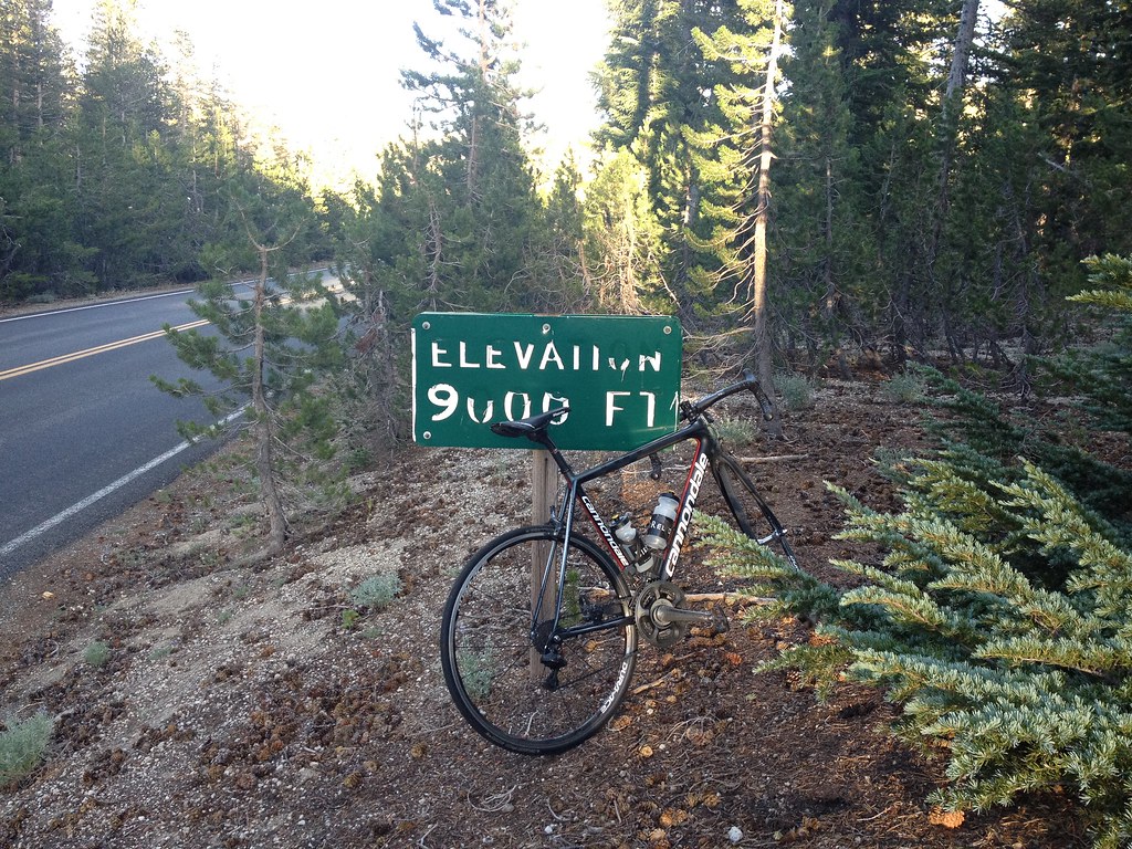
I wish to nominate Dawson Saddle for another of California’s Toughest Climbs  additional links here and here .  Dawson Saddle is 32 miles and gains 7,500 feet.  But there’s more difficulty to this climb than just the mileage and the gain.  If you plan on tackling the climb to Dawson Saddle please follow these tips to ensure safe travels:

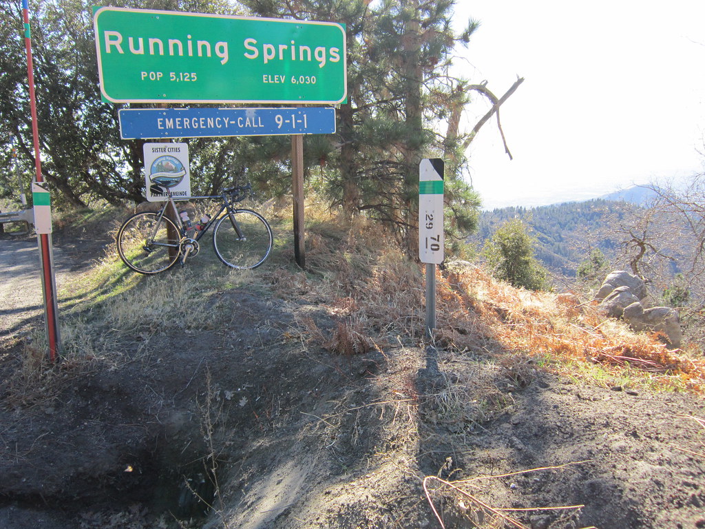
1.  If you want a short warm-up and then begin climbing straightaway you should start at Encanto Park approximately 660 feet above sea level

2.  In the summer months, I would start the climb with a minimum of three bottles.  I have done it with five bottles.  Never a bad thing to have “too much fluids/nutrition”

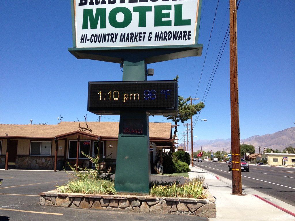
3.  In the summer months, expect temperatures over 90 degrees F at the lower elevations

4.  Bring at least five hours of nutrition Minimum three-hour climb, Recovery at the summit and then nutrition for the long descent. The descent is not a high-speed descent because of the road conditions which you should note on your climb.  There are sections were you can open it up as well, so to speak.

5.  There isn’t anywhere to get fluids once you begin the climb

6.  There is a stream coming through the rocks at about 4,000 feet elevation – drink at your own risk!

7.  In May and June you should plan to reach the summit and begin your descent before 3 pm – temperatures drop very quickly as the sun sets  The “sun sets” sooner because you are surrounded by higher mountain peaks in the area and you lose the Sun’s heat earlier

8.  Bring a vest and arm/knee warmers and light full-fingered gloves as a minimum.  I HIGHLY recommend wool! Standard issue of clothing if you wish to a summit bagger!

9. Unless you are a strong climber bring at least a 27 tooth cassette (11-27 or 11-28) or a compact crankset 50/34.  I have done this climb with a 53/39 and 11-23 cassette but I wouldn’t recommend that for everyone.

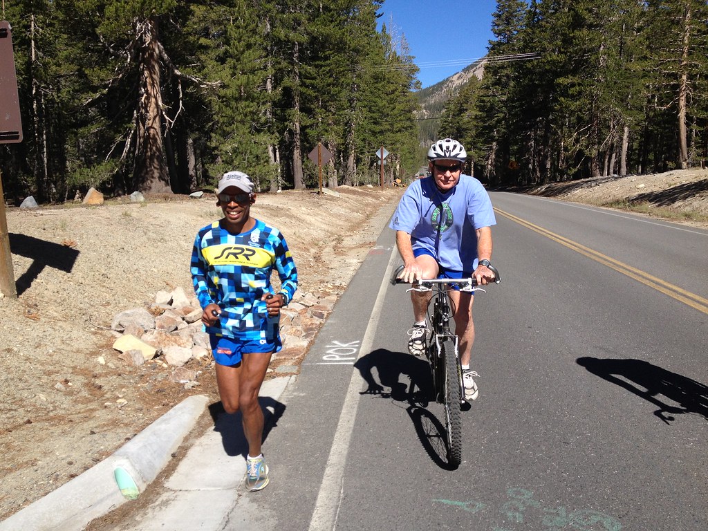
10. Bring a buddy this is a remote climb, with closed roads to vehicular traffic, cell coverage is spotty to non-existent.  I would go on the assumption that there’s isn’t cell coverage.    Wildlife can and should be expected such as bears, deer and squirrels.  Yes squirrels, they are dangerous because they are unpredictable and cross your path then double back across your path again – a recipe for disaster.

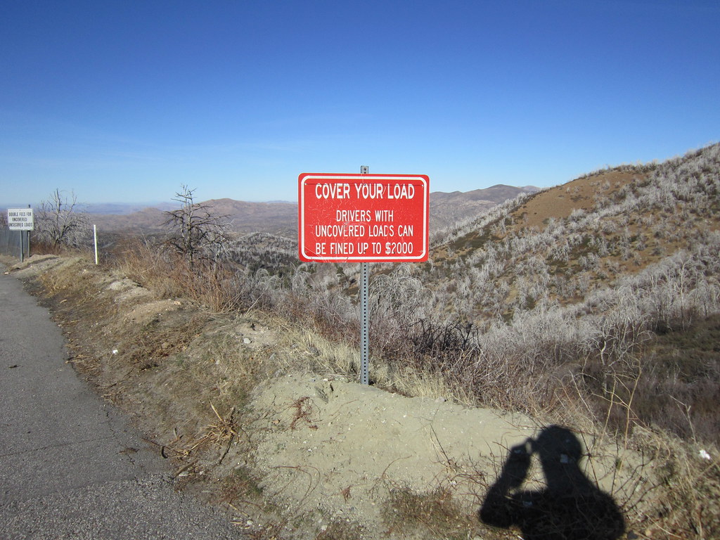
11.  Bring plenty of flat repair- even though the road has been cleaned significantly over the years I have been doing this climb the roads are not maintained, frost heaves, potholes, plenty of loose rock, and falling rock are strewn along the highway.  I bring tire boots but a spare tire is not a bad idea.

12.  Be prepared to ride at least five hours without seeing another cyclist and once you pass the gated areas you won’t see any cars.

13.  Descend with caution- it could be hours or even days before someone finds you!

14.  File a flight plan- Tell a loved one or a friend where you are going and when you are expected back.  I have always called/texted my loved one with three simple words “on the mountain” and then “off the mountain”

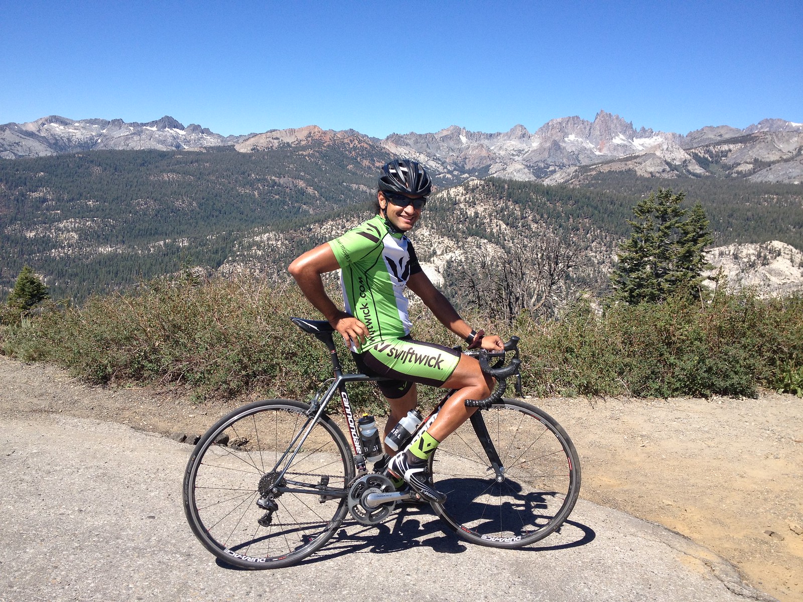
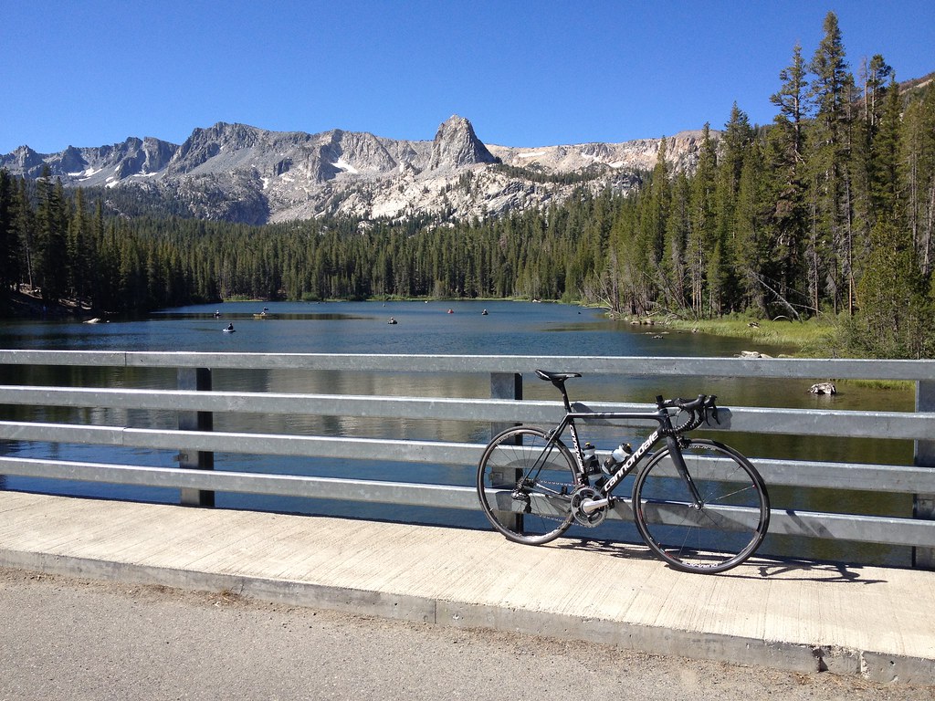
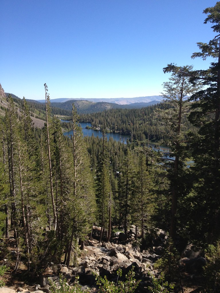
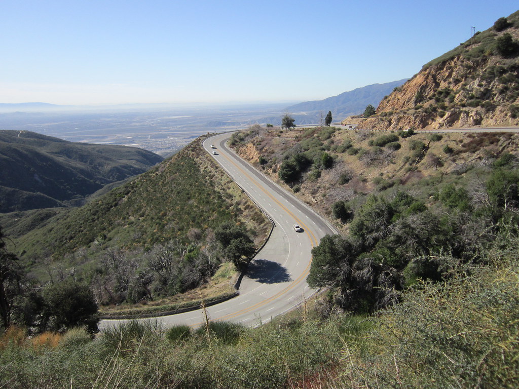
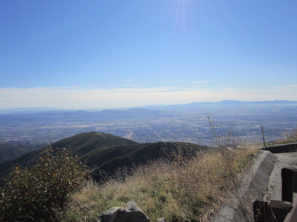
15.  Lastly enjoy the views they are spectacular!

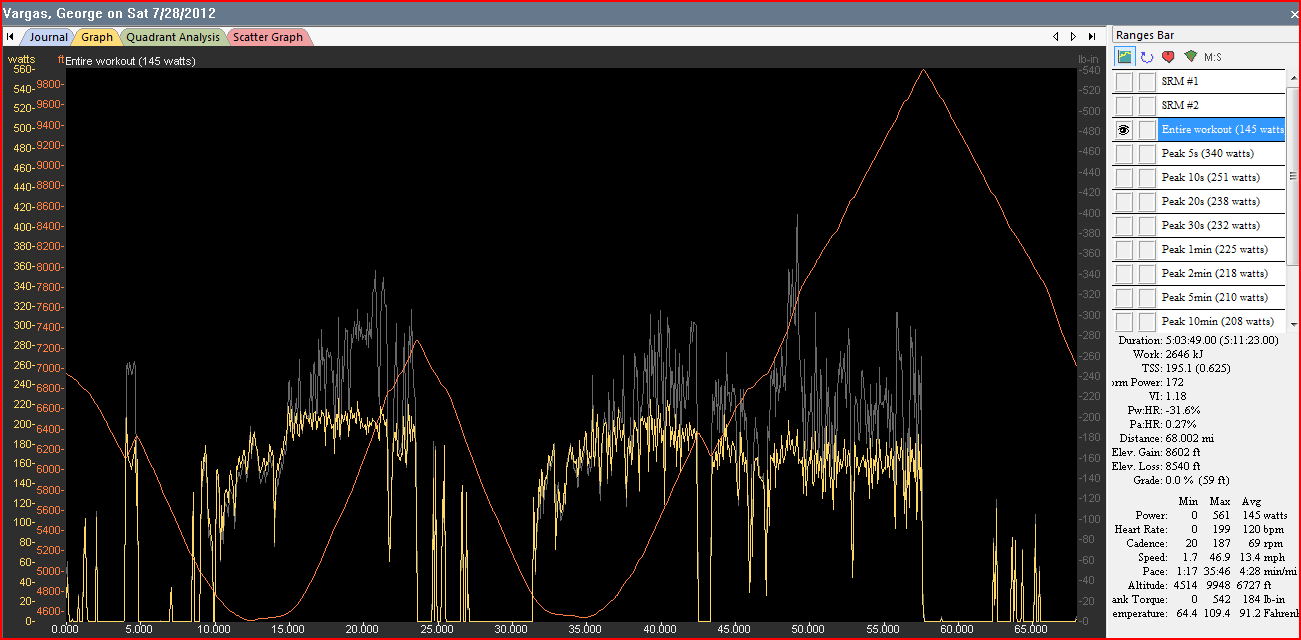
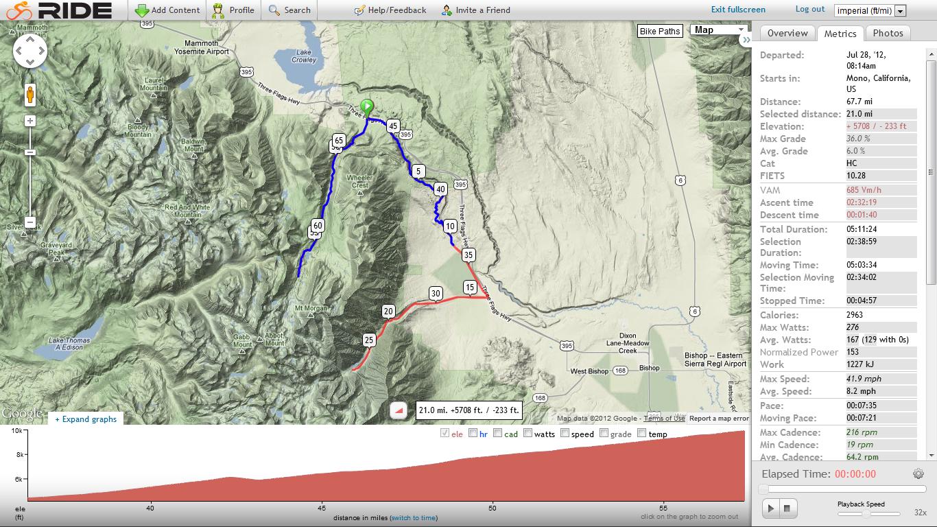
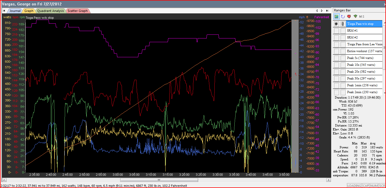
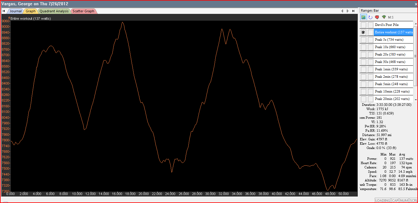
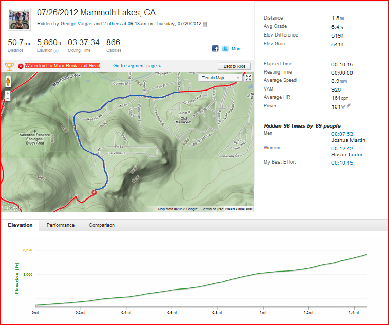
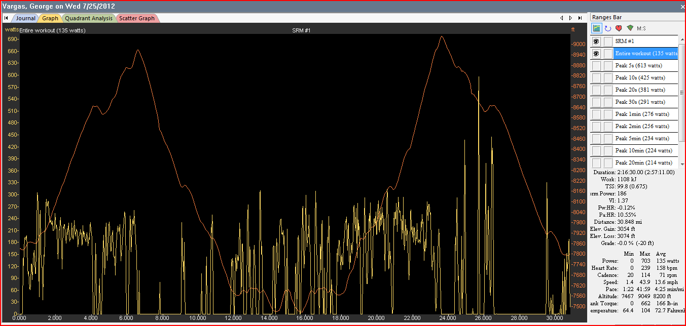
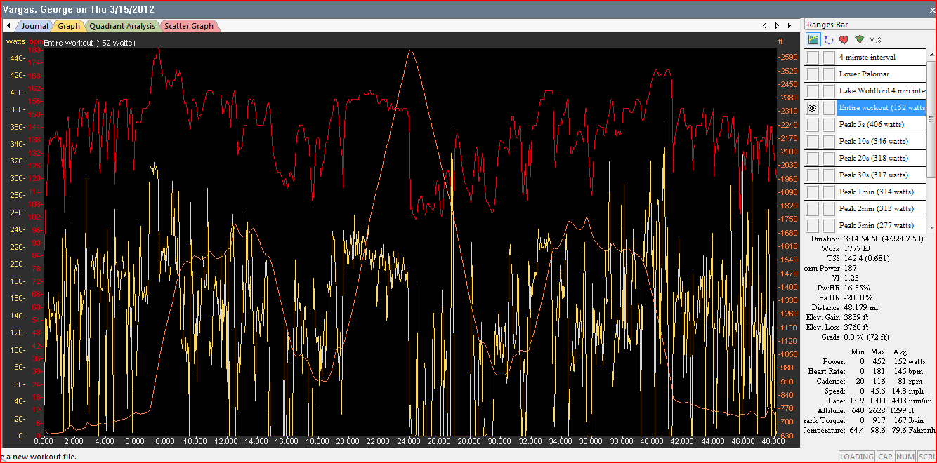
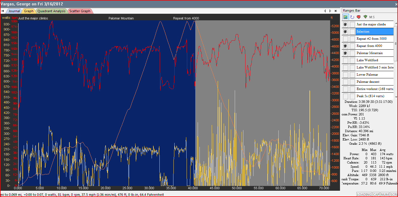
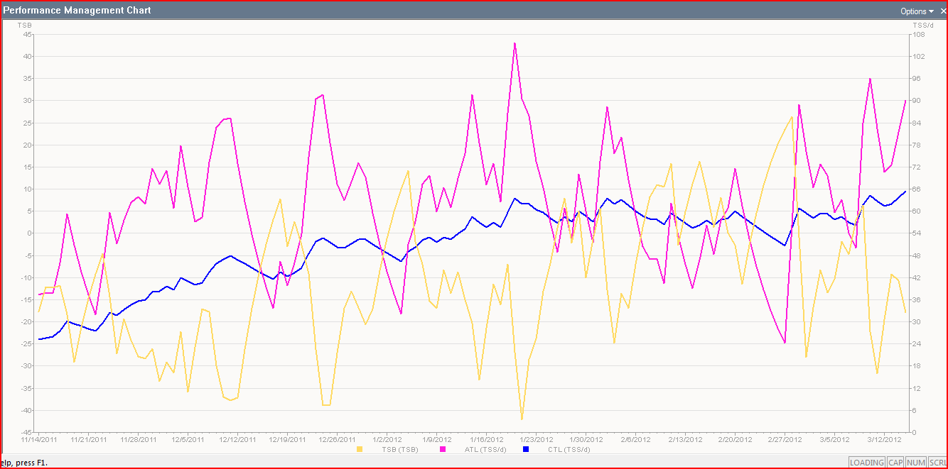
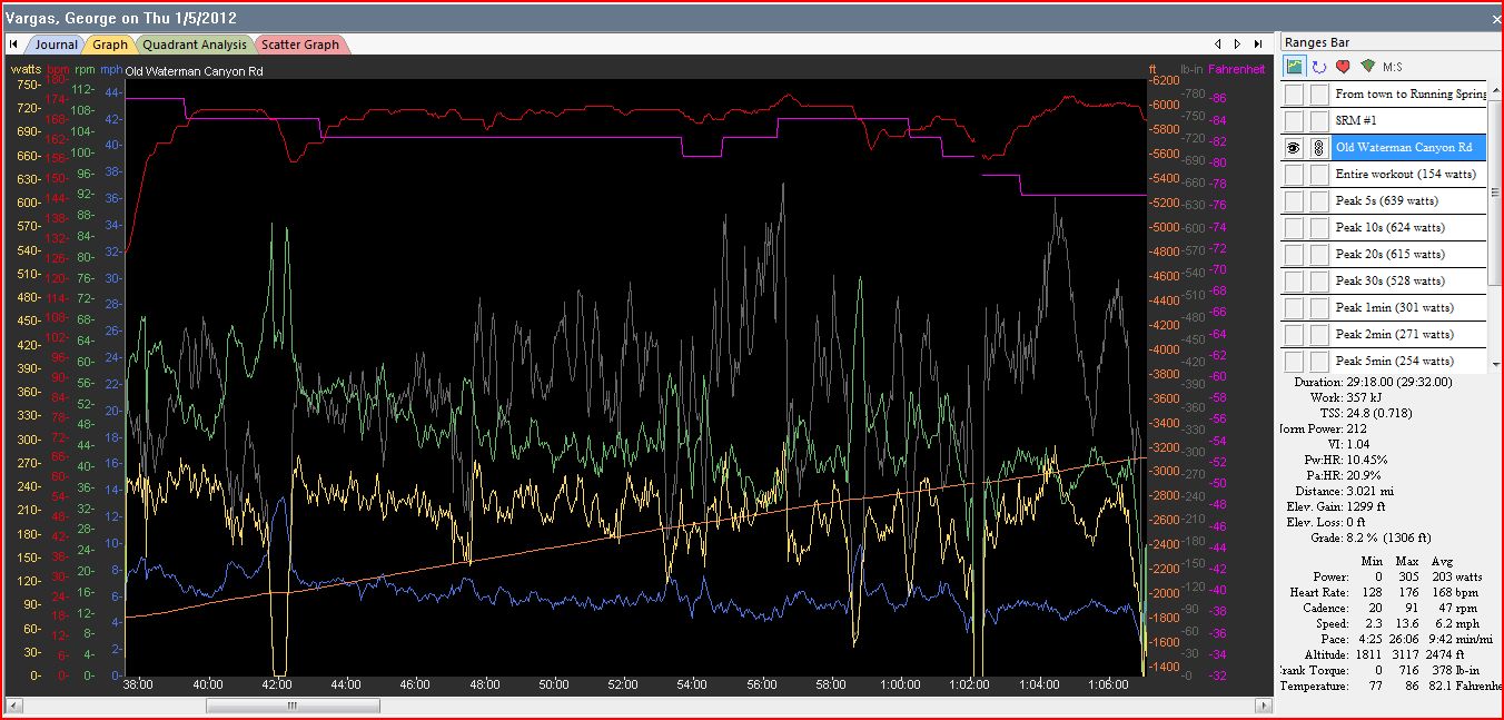
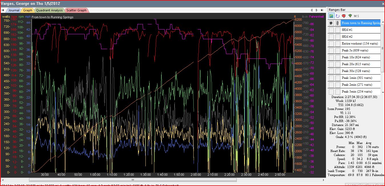
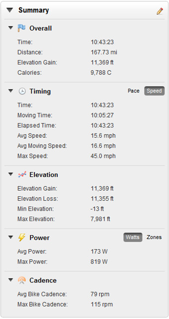
Training Peaks screenshot of Dawson Saddle Climb Normalized Power 201 or 3 w/kg for 3 hours

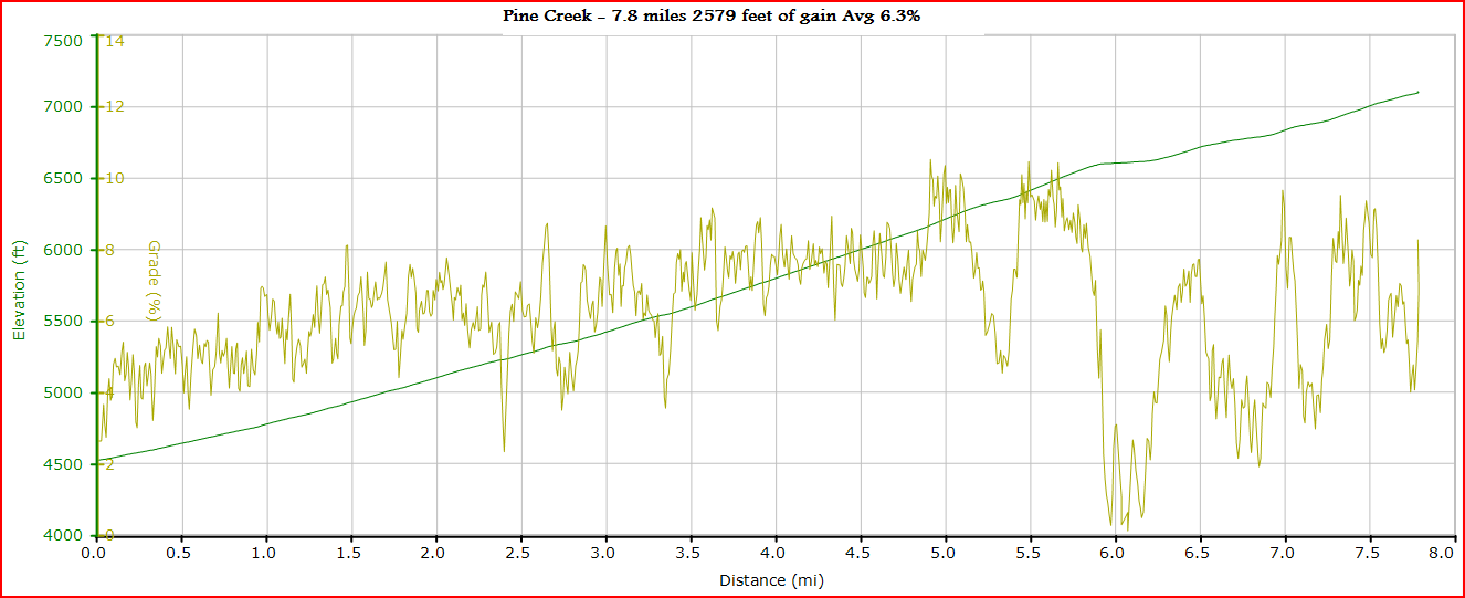
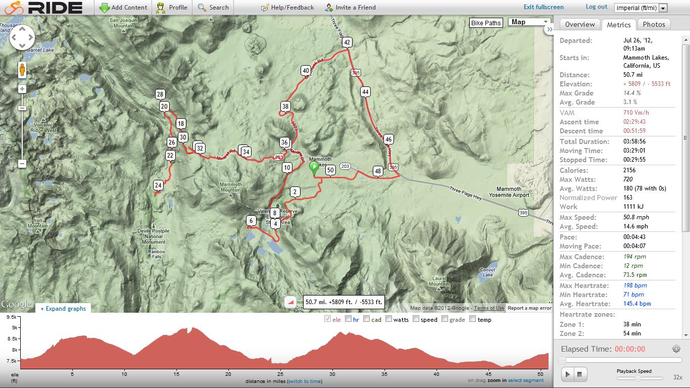
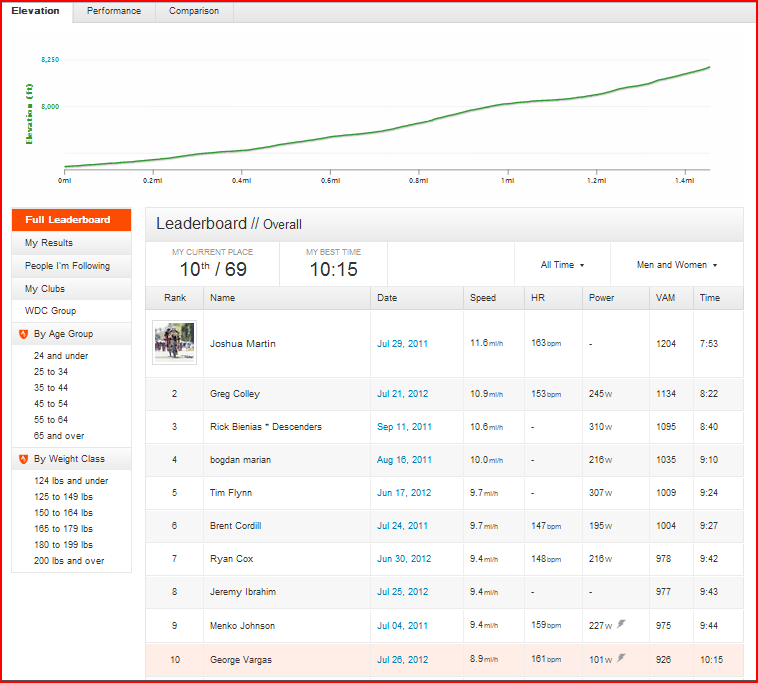
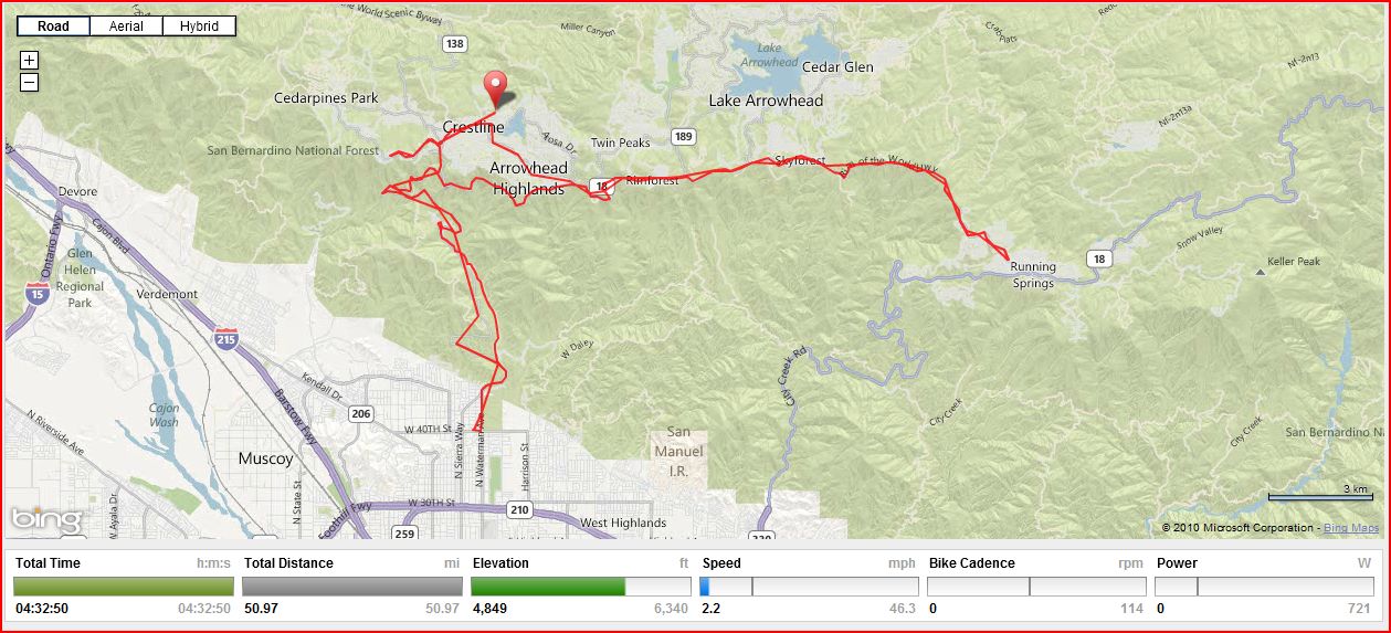
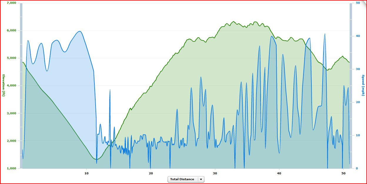
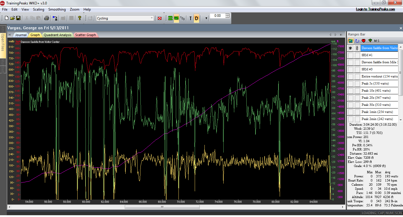
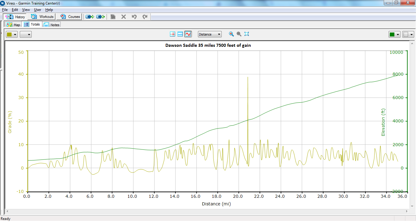
Grade analysis of Dawson Saddle from the Public Restroom at mile 35.25 on the San Gabriel River Trail

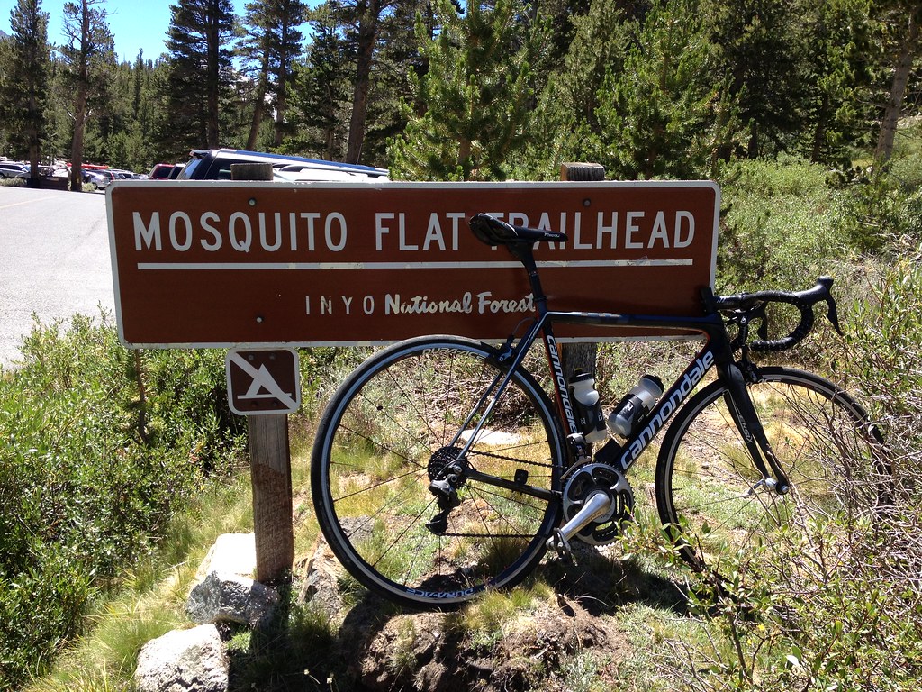
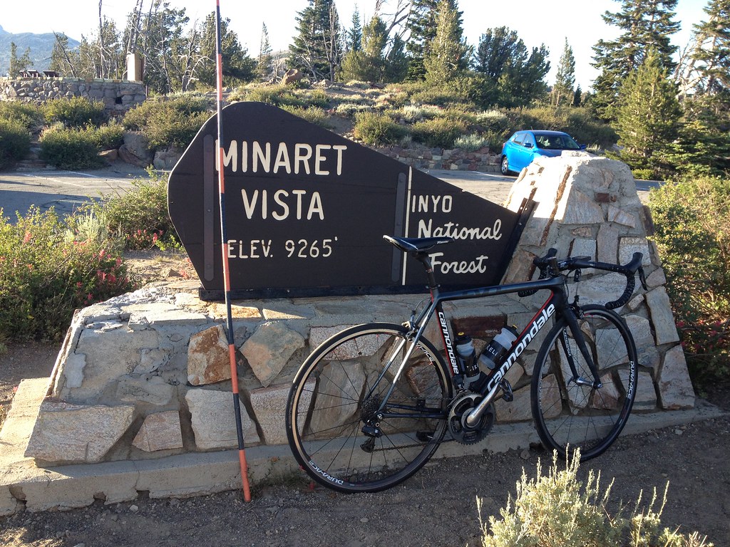
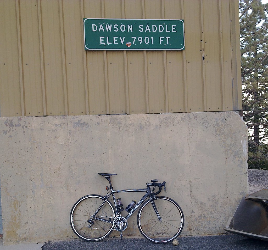
Felony – my 2011 Felt F1 with Shimano Di2

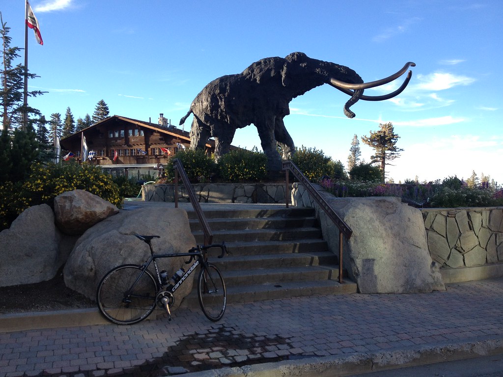
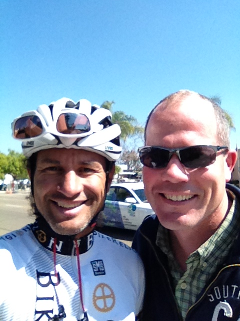
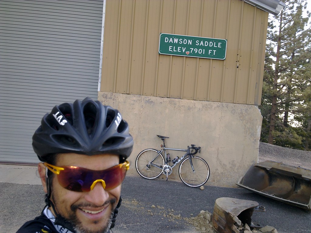
George “Red-Eyed Vireo” Vargas summits Dawson Saddle on his 2011 Felt F1 with Di2- 32 mile 7,500 feet of gain climb

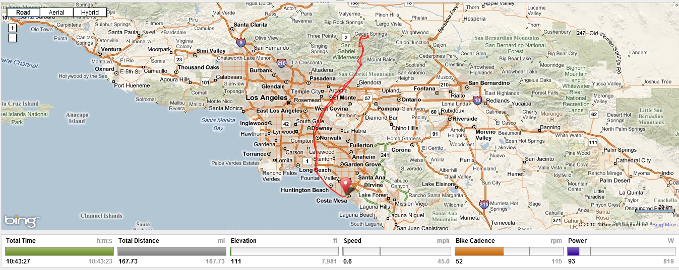
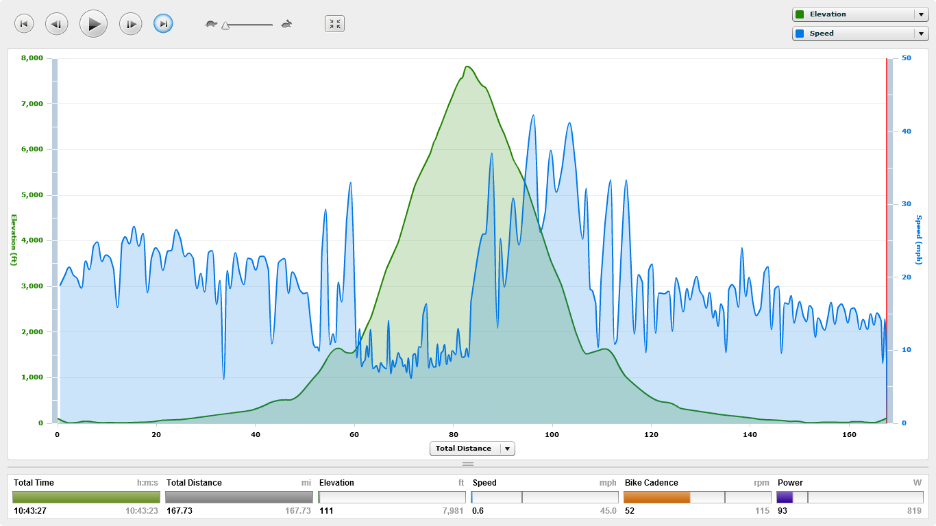
My ride yesterday was from Newport Beach to Dawson Saddle 168 miles with 11,000 + feet of climbing. I left Newport Beach close to 1pm.  My plan was to do some night riding at the tail-end of my ride.  I was stocked with 10 hours of nutrition.  I ran out of fuel 9 hours into the ride.  It took me almost 11 hours to get home.  I bonked badly.  I rode 126 miles the day before and because of  it I was much hungrier on this ride.  My route was North on Pacific Coast Hwy (PCH)  to Seal Beach and then the San Gabriel River Trail (SGRT) to Hwy 39 to Angeles Crest Hwy 2 to Dawson Saddle summit 7901 elevation.  It’s important to mention that the  Dawson Saddle summit is 84 miles into my ride.  This climb is hard enough from Encanto Park where you get a couple miles of warm-up and just go.  Now imagine starting this climb with 50 miles on your legs.  Or how about this after summiting realizing you are still 84 miles from home.

his ride is especially difficult SOLO and unsupported.  You must carry enough fluids and nutrition from the start to a public restroom at mile 35.25 on the SGRT – about 50 miles for me.  Then refuel and have enough fuel/fluids for the next 35 miles of climbing – at least 3 hours of climbing.  You should have enough nutrition and fluids to have something at the summit and for your descent.  The descent takes a little longer than normal because the road conditions are not ideal in certain areas.  Basically you need enough of  whatever you fancy for 70 miles with 3+ hours of hard climbing in a remote closed road section.  Then once you refuel at the public restroom you need enough fluids/fuel to get you 35 miles back to PCH and then home if you don’t want to stop again.  Can you say Epic Adventure?!?!?!

Thank you for reading my blog.  Please provide me with feedback as to whether you find this post useful before or after doing your climb.  Please pass this blog on to your climbing friends.

Here are a few other posts I have made on climbing Dawson Saddle

September 29, 2008

May 14, 2010

May 27, 201