Based on a FIETs calculation, which is explained in much more detail in a previous post, here is the top 100 toughest climbs in California. Summer time is coming how many can you knock off this list?


Based on a FIETs calculation, which is explained in much more detail in a previous post, here is the top 100 toughest climbs in California. Summer time is coming how many can you knock off this list?
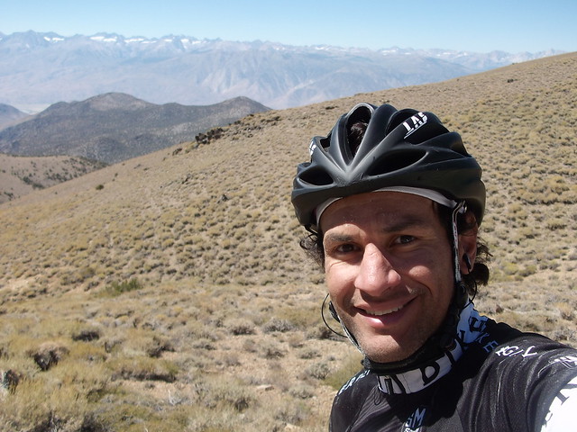
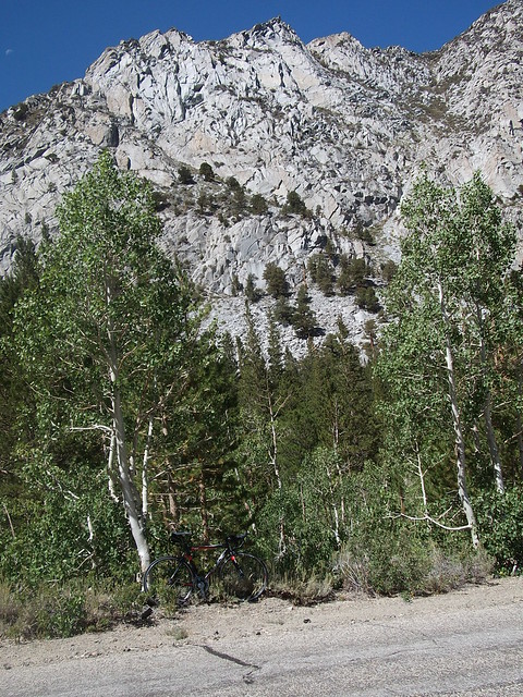
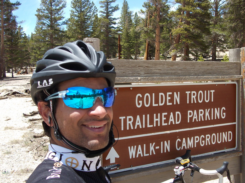
As I sit here daydreaming of an epic climbing weekend, yes epic, an overused word but more on that later, I just can’t contain myself. I am counting down the days until I am free to fly in nature’s most amazing playground – the mountains. Is it only Wednesday? I check the calendar again and yes it is only Wednesday darn! Where am I going and why am I as excited as when I watch brown Santa (UPS driver) pull up at my door? I’m headed to the Eastern Sierra Mountains of California!
I’m sure you thought I must be headed off to Europe. Or possibly you thought I must be headed to Colorado. No, I’m driving, yes driving, a few short hours, depending on traffic ugh traffic, a mere 274 miles to Lone Pine, CA for some of the best climbing in California. I will take it one step further and state unequivocally, some of the best climbing in the United States. The Eastern Sierras have some of the hardest climbs in the country in a small and concentrated area. Taking on one of these legendary climbs is a great acheivement but having them so conveniently close to each other enables you to tackle a second and possibly, if you are as nutty as I am, you might take on a third massive climb.


We all value things differently. Our value systems allow us to rank and prioritize things that are important to us. What I value in a climb is how much I will be challenged by it and how great my sense of accomplishment will be when I summit. For some it may be the scenery and surroundings. I understand that as well. However, for me the scenery comes second to the suffering while I’m climbing. Once I summit well then it is ALL about the view!
Now I’m not completely delusional sure I would like to take off to Europe and climb the mountains that have been made famous by the mano a mano battles of my cycling heroes during the Grand Tours. But when time and finances are an issue you can find the most amazing climbing adventures right here in Southern California. No flying, no customs, no worrying about how to get your bike to Europe and back from Europe in one piece and let’s not forget the 9 hour jet lag issues and so on …
Who’s the GOAT?
Do you often find yourself debating with your friends “What are some of the hardest climbs you have done?” This is akin to the other never-ending circular debate “Who is the G.O.A.T? Who is the greatest of all time?” insert sport here _________ And like the GOAT argument I wish to arm you with the facts and stats that we as climbers use to back up our argument. Once you understand them you can use them the next time you fall into the “what is the hardest climb?” trap. I have had this debate for years. So I wish to introduce you to FIETS. What is it? Let’s find out together. Oh and you can thank me later for the tables and graphs.
What is FIETS?
FIETS is a formula for ranking climbs.
The Fiets Index (developed by the Dutch cycling magazine Fiets).
The actual formula is: [H^2/D*10] + (T-1000:1000; but only if greater than 0)
Note: Only add T-1000 if that number is greater than zero.
Let me simplify things for you … the higher the FIETS, the harder the climb, and the higher it will rank on a list. If you want a little more explanation of the formula then think of these three things — how much will you climb, in how much distance and what is its height.
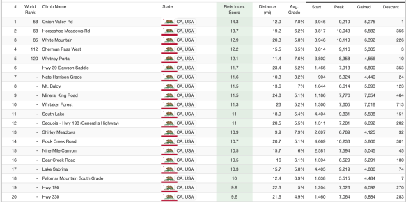
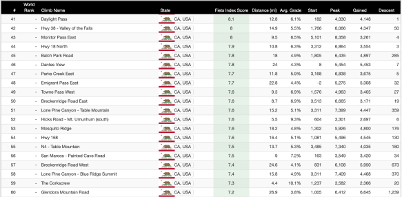
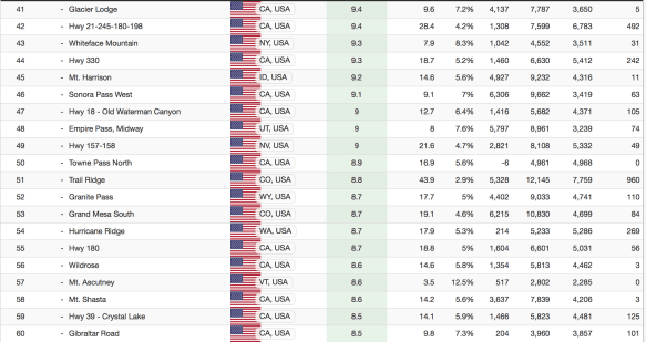
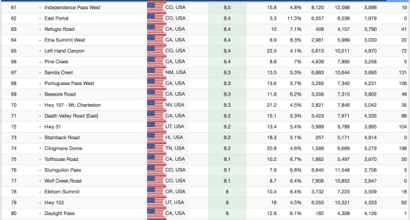
The good people over at PJAMM Cycling have taken the time to construct and maintain an excellent interactive website with climbs from the US and all over the world. It is a valuable resource if you love climb, love numbers and data like I do. I have thoroughly enjoyed pouring over the lists which may be sorted in multiple ways. One such sorting is listing the climbs in the US by the highest FIETS which as you may recall from just one paragraph ago means the toughest. I wish to provide for you a few observations. Please bare with me as some may be plain as day but I hope to bring even the novice climber up to speed along with the elite climber.
Hawaii tops the list with the first and second hardest climbs in the US – Mauna Kea and Haleakala, respectively. Mauna Kea has a FEITS of 28.9 and it also has the unique distinction of being the hardest climb in the world. The stats are mind boggling – 42.6 miles long, gaining 13,778 feet, with an average grade of 6.1% Haleakala is no slouch either but its FIETS at 18.2 is nearly half that of Mauna Kea! It’s numbers are: 35.6 miles long, gains 10,059 feet, at an average of 5.3% . As any experienced climber knows the average grade just means that most of the climb is more than the average grade stated.
Now that we have dispensed with the huge volcano climbs of Hawaii let’s move back to the mainland. I created a small table below to illustrate, again in numbers, my mind works best this way, where the rest of the hard climbs are in this great country of ours. Excuse my rudimentary spreadsheet skills please.

It becomes glaringly obvious to anyone, even at glance, that California ranks consistently with the highest number of hard climbs in each bucket of 20 climbs for the top 100 climbs. It also doesn’t take a math whiz to see in the final tally that 46 climbs out of 100 climbs or 46% of the nation’s hardest climbs are located right here in California.
Another observation, which was rather illuminating to me, was that Colorado ranked much lower than I expected. Aside from their two world famous, 14’ers Mt Evans and Pikes Peak in the top 20, they don’t have another strong showing until climbs 61-80 with five in that category. Mt Evans and Pikes Peak are still on my wish list. I tackled a 14’er here in California, White Mountain Peak, which shows up on the top 20 list as #9 but only up to 10,114 elevation. You can then continue on White Mountain when the paved road runs to dirt up to the summit at 14,252. Not recommended on a Cyclo Cross bike only a crazy person would do that – who me? Yeah me it was very challenging to say the least! Take a hard tail MTB instead.
Yes yes but Colorado has the altitude. Fair point. However, I submit to you that not everyone is effected by altitude. I have ridden above 10,000 feet in race conditions and I felt the usual effects of reduced power but not the most common complaint of not being able to breathe under effort. So not everyone will feel the effects of altitude but everyone will feel the effects of the length of a climb and the steep gradients, those are very tangible. Length and steep gradients is what California offers in abundance.

Even more surprising to me was how well Utah ranked with a total of 11 climbs and a good showing in each bucket of 20 climbs. It seems like you can get plenty of good climbing there as well.
Below are screenshots from the PJAMM website. It can’t be overstated how much work they have put into their website.


Then I got to thinking wow that is a lot of climbs in California and some of these names sounded familiar. So how many of the California climbs have I done? This part of my research was much more fun. It turns out that:
Top 20
I have done eight out of eight of the hardest climbs in California!
Top 40
I have completed nine of the 11 climbs – not bad. The two I haven’t done I just haven’t heard of them. I need to locate, close with and destroy the enemy … oh wait that is the former Marine coming out. What I mean is I need to find out where they are and get them done.
Top 60
I have completed nine of the 11 hardest – One of which I may never do. Hwy 330 is just too narrow and too dangerous and the other I just put on my hit list. There I go again – I mean checklist.
Top 80
I have completed three out of eight climbs. Interesting to see a few on there that I didn’t know existed or that ranked in the top 80 so I can knock them off fairly easily but I need to travel to them.
Top 100
I have completed seven of the eight. Same story there is a climb on the list I haven’t heard of before this exercise.
Still daydreaming …
I haven’t made my plan yet for this weekend’s rides but know that they will be epic. Oh yeah I was going to talk more about the overuse of the word. I will just give you my 2 cents on the subject. Far too many use the word too loosely. The short of it is — to me EPIC is something that either weather, mechanicals, terrain, duration or a combination of these four attributes but not limited to them, cause you to experience great elation, despair, sense of accomplishment, suffering, soul searching, personal growth or a combination of these attributes but not limited to them, and yet you complete the event, race or training session and you say “one and DONE! there is no way I’m doing that again”. But alas, the entry window opens up for next year and you sign up again. For the long of it I will have to publish a post about epic adventures to give you some sense of what I consider to be EPIC. Your experience may vary.
Is it still Wednesday? yes urg!


Tomorrow I will be riding the Mt Whitney Super Century. Here is the SPOT Transmitter link if you care to follow on the SPOT page.
Thank you Brad Horton for the use of the SPOT Transmitter.
http://share.findmespot.com/shared/faces/viewspots.jsp?glId=0Po3rlAvZRhphLYqLgPtFWXFqBnoazRkk
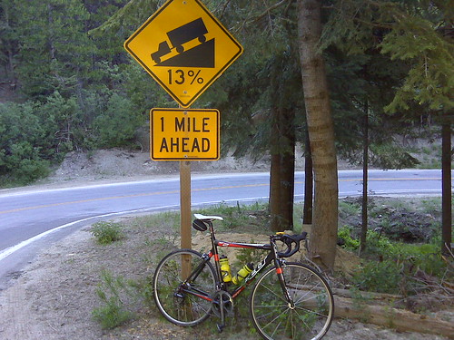
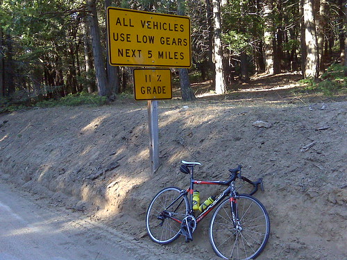
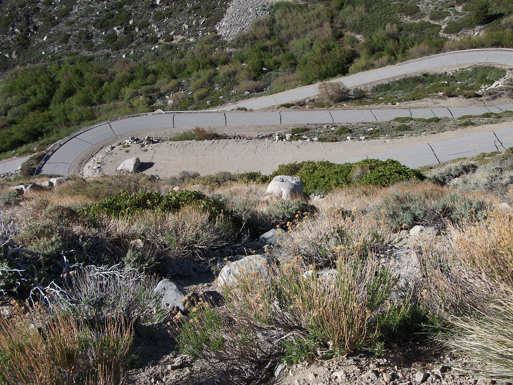
I wish to nominate Dawson Saddle for another of California’s Toughest Climbs additional links here and here . Dawson Saddle is 32 miles and gains 7,500 feet. But there’s more difficulty to this climb than just the mileage and the gain. If you plan on tackling the climb to Dawson Saddle please follow these tips to ensure safe travels:
1. If you want a short warm-up and then begin climbing straightaway you should start at Encanto Park approximately 660 feet above sea level
2. In the summer months, I would start the climb with a minimum of three bottles. I have done it with five bottles. Never a bad thing to have “too much fluids/nutrition”
3. In the summer months, expect temperatures over 90 degrees F at the lower elevations
4. Bring at least five hours of nutrition Minimum three-hour climb, Recovery at the summit and then nutrition for the long descent. The descent is not a high-speed descent because of the road conditions which you should note on your climb. There are sections were you can open it up as well, so to speak.
5. There isn’t anywhere to get fluids once you begin the climb
6. There is a stream coming through the rocks at about 4,000 feet elevation – drink at your own risk!
7. In May and June you should plan to reach the summit and begin your descent before 3 pm – temperatures drop very quickly as the sun sets The “sun sets” sooner because you are surrounded by higher mountain peaks in the area and you lose the Sun’s heat earlier
8. Bring a vest and arm/knee warmers and light full-fingered gloves as a minimum. I HIGHLY recommend wool! Standard issue of clothing if you wish to a summit bagger!
9. Unless you are a strong climber bring at least a 27 tooth cassette (11-27 or 11-28) or a compact crankset 50/34. I have done this climb with a 53/39 and 11-23 cassette but I wouldn’t recommend that for everyone.
10. Bring a buddy this is a remote climb, with closed roads to vehicular traffic, cell coverage is spotty to non-existent. I would go on the assumption that there’s isn’t cell coverage. Wildlife can and should be expected such as bears, deer and squirrels. Yes squirrels, they are dangerous because they are unpredictable and cross your path then double back across your path again – a recipe for disaster.
11. Bring plenty of flat repair- even though the road has been cleaned significantly over the years I have been doing this climb the roads are not maintained, frost heaves, potholes, plenty of loose rock, and falling rock are strewn along the highway. I bring tire boots but a spare tire is not a bad idea.
12. Be prepared to ride at least five hours without seeing another cyclist and once you pass the gated areas you won’t see any cars.
13. Descend with caution- it could be hours or even days before someone finds you!
14. File a flight plan- Tell a loved one or a friend where you are going and when you are expected back. I have always called/texted my loved one with three simple words “on the mountain” and then “off the mountain”
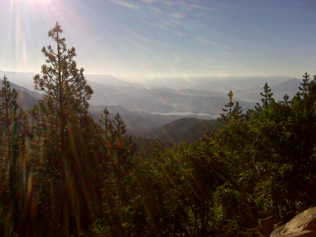
15. Lastly enjoy the views they are spectacular!
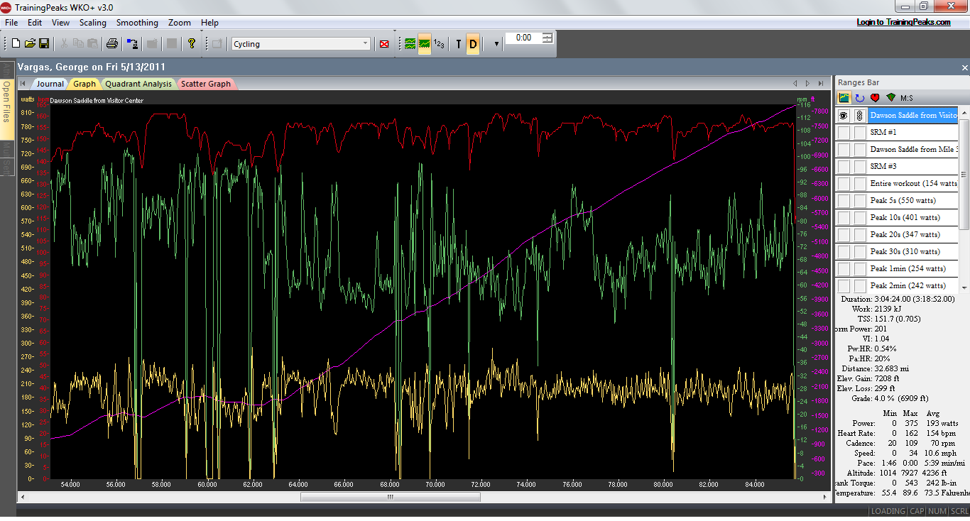
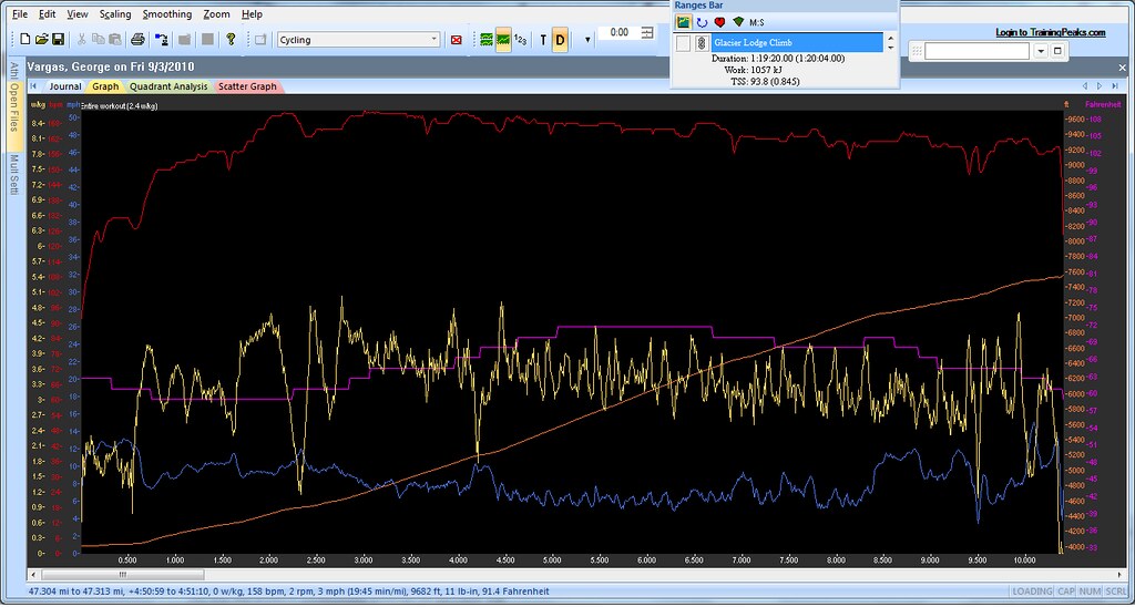
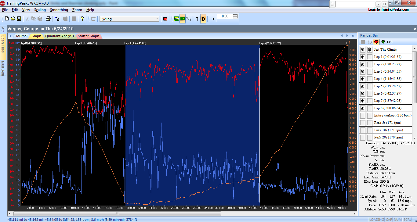
Training Peaks screenshot of Dawson Saddle Climb Normalized Power 201 or 3 w/kg for 3 hours
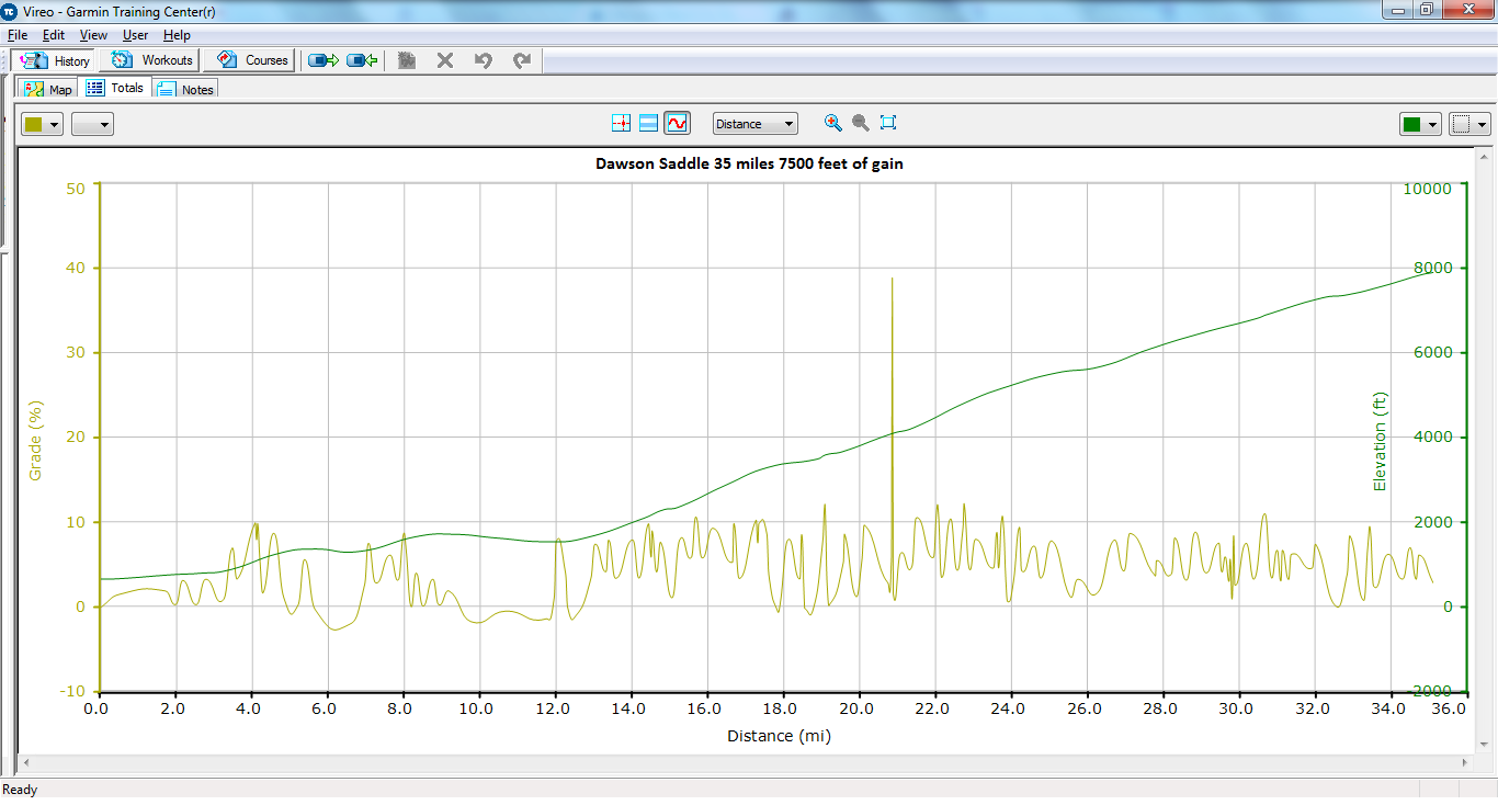
Grade analysis of Dawson Saddle from the Public Restroom at mile 35.25 on the San Gabriel River Trail
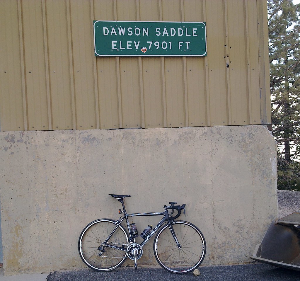
Felony – my 2011 Felt F1 with Shimano Di2
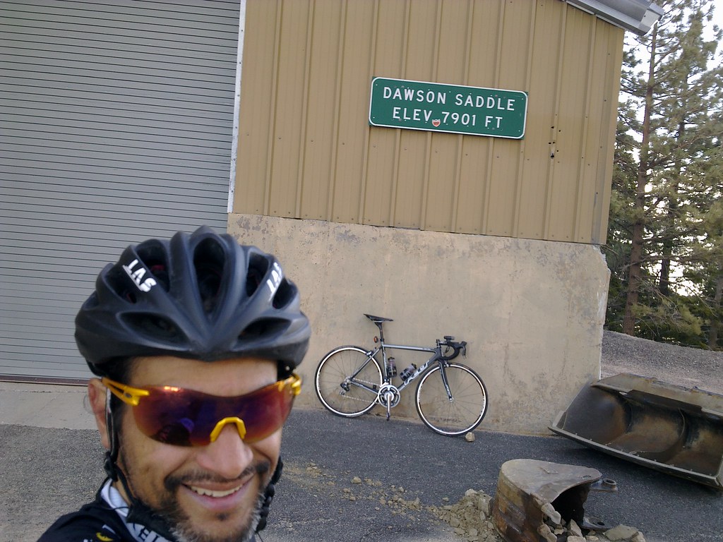 George “Red-Eyed Vireo” Vargas summits Dawson Saddle on his 2011 Felt F1 with Di2- 32 mile 7,500 feet of gain climb
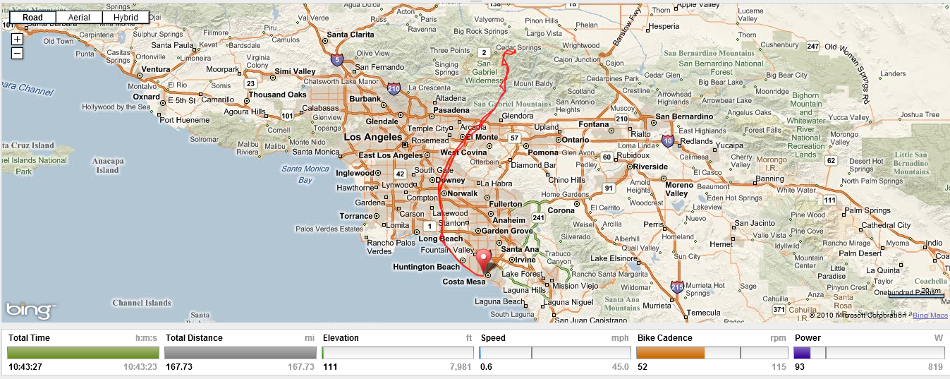
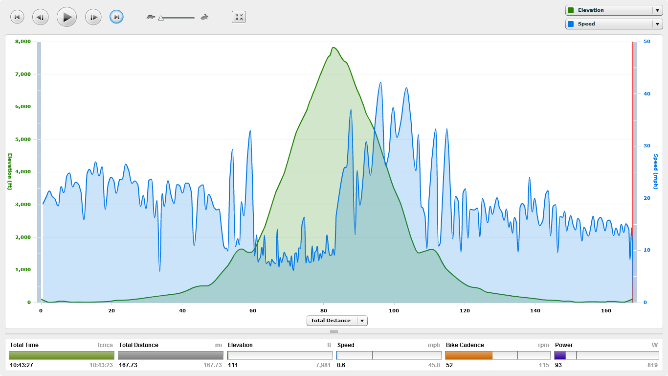
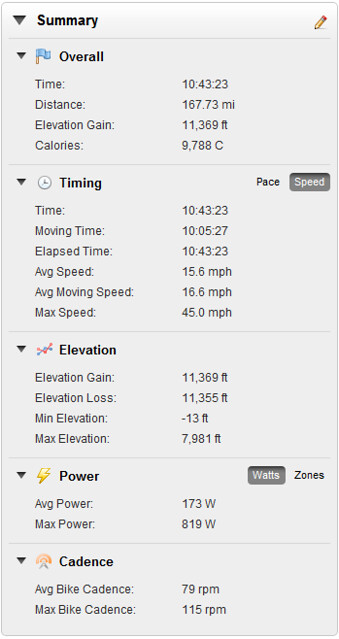
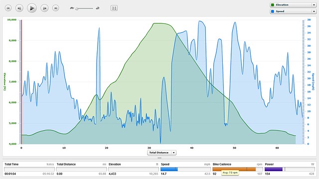
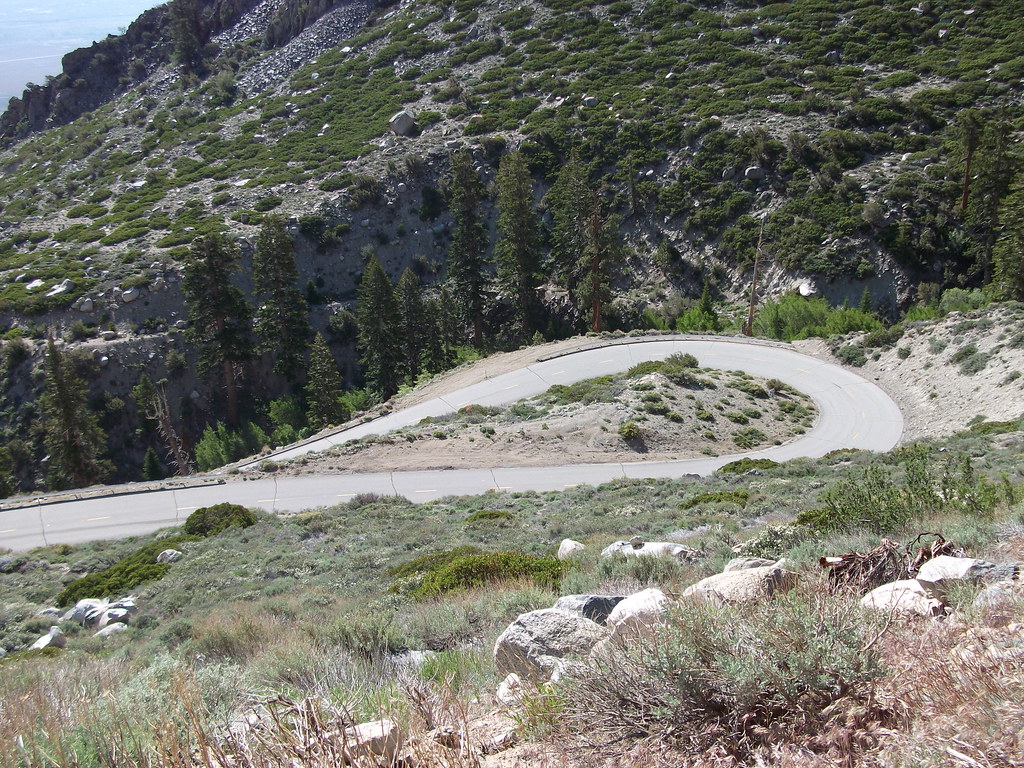
My ride yesterday was from Newport Beach to Dawson Saddle 168 miles with 11,000 + feet of climbing. I left Newport Beach close to 1pm. My plan was to do some night riding at the tail-end of my ride. I was stocked with 10 hours of nutrition. I ran out of fuel 9 hours into the ride. It took me almost 11 hours to get home. I bonked badly. I rode 126 miles the day before and because of it I was much hungrier on this ride. My route was North on Pacific Coast Hwy (PCH) to Seal Beach and then the San Gabriel River Trail (SGRT) to Hwy 39 to Angeles Crest Hwy 2 to Dawson Saddle summit 7901 elevation. It’s important to mention that the Dawson Saddle summit is 84 miles into my ride. This climb is hard enough from Encanto Park where you get a couple miles of warm-up and just go. Now imagine starting this climb with 50 miles on your legs. Or how about this after summiting realizing you are still 84 miles from home.
his ride is especially difficult SOLO and unsupported. You must carry enough fluids and nutrition from the start to a public restroom at mile 35.25 on the SGRT – about 50 miles for me. Then refuel and have enough fuel/fluids for the next 35 miles of climbing – at least 3 hours of climbing. You should have enough nutrition and fluids to have something at the summit and for your descent. The descent takes a little longer than normal because the road conditions are not ideal in certain areas. Basically you need enough of whatever you fancy for 70 miles with 3+ hours of hard climbing in a remote closed road section. Then once you refuel at the public restroom you need enough fluids/fuel to get you 35 miles back to PCH and then home if you don’t want to stop again. Can you say Epic Adventure?!?!?!
Thank you for reading my blog. Please provide me with feedback as to whether you find this post useful before or after doing your climb. Please pass this blog on to your climbing friends.
Here are a few other posts I have made on climbing Dawson Saddle
ONION VALLEY COMPARED TO MT VENTOUX, FRANCE
TRAINING GOAL– Monthly fitness test on Onion Valley Rd (tempo/threshold)
BIKE SETUP – 53/39 Dura-Ace 7900 Wireless SRM Crankset and 11-28 Cassette.
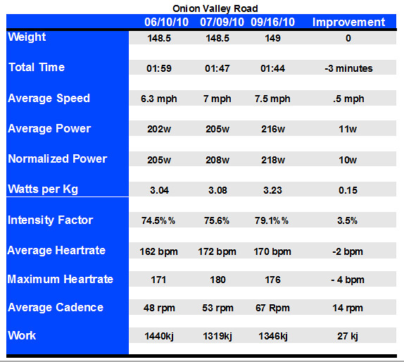
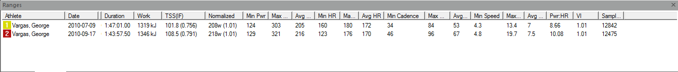
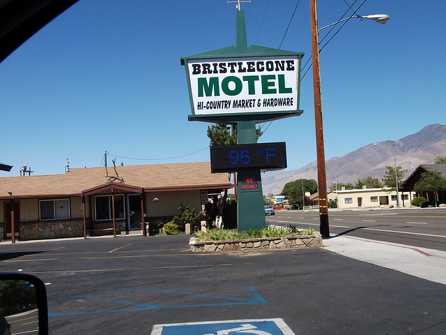
On 9/17 I climbed Onion Valley Rd to a Personal Record (PR) of 1 hour 44 minutes. It’s a 13 mile climb that gains over 5,000 feet in one solid shot. There are no flat spots or dips in this climb which makes this an extremely hard climb. Take for example Mount Palomar — after climbing a 5 miles you get a 3/4 mile flat section before beginning the final 6.7 miles at 7% to the summit. Or Mosquito Flat where you have a .9 mile dip 8 miles into the climb and a couple sections of fairly gently grades. Or Ancient Bristlecone/White Mountain were about 8 miles into the climb you have a 1 mile flat section before continuing on White Mountain Road to the 10,000 foot summit.
On 9/16 I climbed Mosquito Flat to a Personal Record of 2 hours 27 minutes. I was going good but I knew I had at least one more climb to do. I also climbed Pine Creek a 7.5 mile climb that was steeper than I remembered it. It’s important to mention what I did on 9/16 because I was surprised how well my legs recovered overnight. I felt really good on Onion Valley. How good?– I kept easing the pace because I thought I would blow up. I eventually fatigued but even looking at my Training Peaks chart you can see the Power curve (Yellow Line) is pretty consistent. I am happy with the consistency and I don’t think I have more than another 5 minutes to cut off this climb — this season. I would need to train a lot more drop some weight and try again next year.
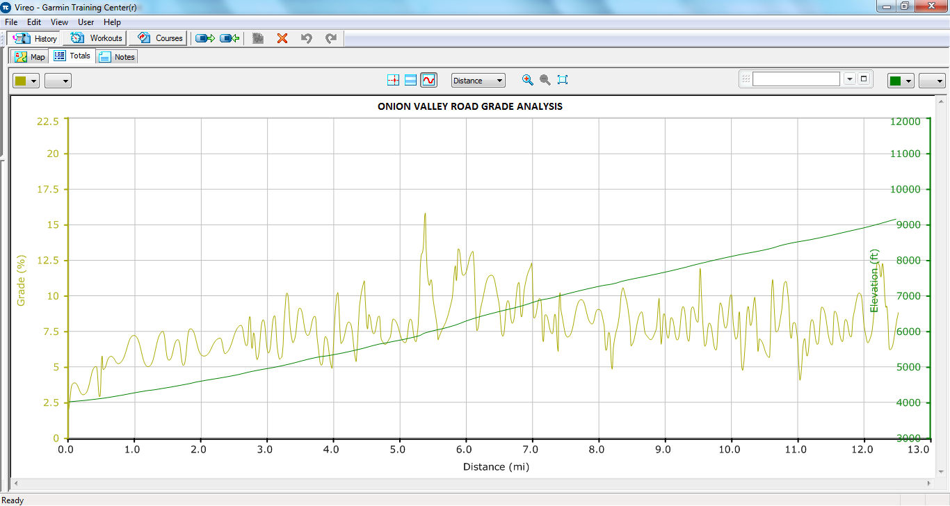
Notice sustained sections above 9% and no dips
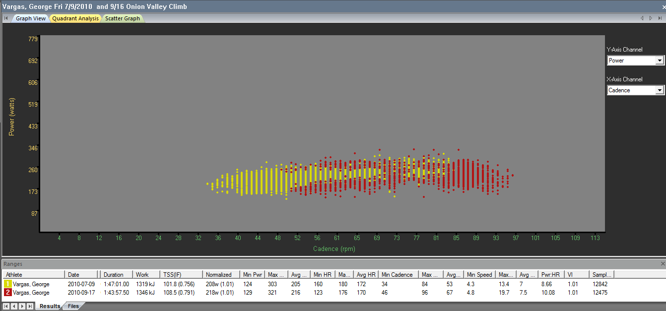
Notice the Red section shows higher cadence for same or more power
George Vargas sets Personal Record on Onion Valley 1 hour 44 minutes. Consistent improvements since June
MFRA from Training Peaks WKO 3.0
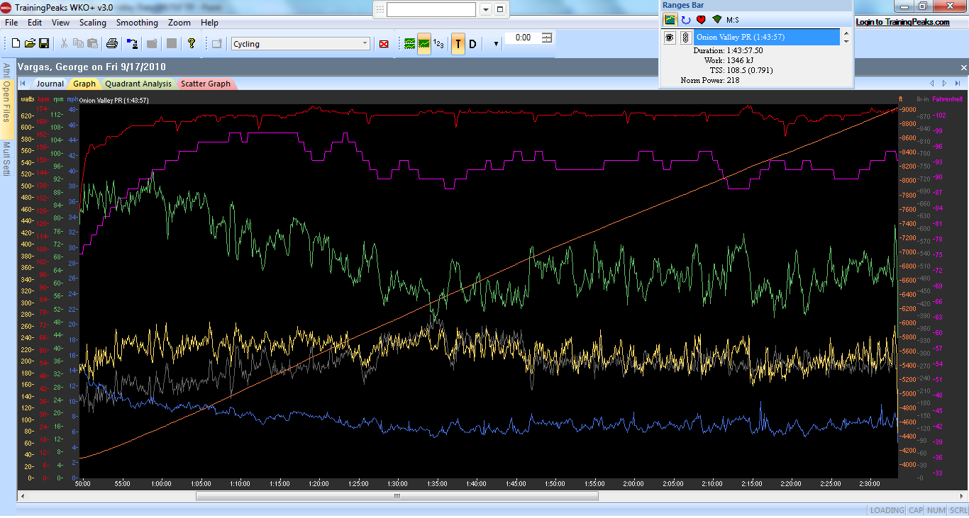
Training Peaks Graph for Onion Valley Rd PR
RED- Heart Rate
PURPLE- Temperature
GREEN- Cadence
YELLOW- Power
GREY- Torque
BLUE – Speed
ORANGE- Elevation

Data for Onion Valley Rd PR
Most Difficult Climbs in California:
1) Onion Valley — DONE 6/10/10 !!
2) Horseshoe Meadows — DONE 6/10/10!!
3) White Mountain– DONE as part of Everest Challenge Stage Race
4) Sherman Pass– DONE 6/24/10!!
5) Whitney Portal — DONE 6/10/10!!
6) Mount Baldy– DONE- too many times to mention
7) Shirley Meadows– DONE 6/24/10!!
8) South Lake– DONE as part of Everest Challenge Stage Race
9) Mount Palomar– DONE 6/06/10!!
10) Mosquito Flat– DONE 09/02/10!!
Additionally, here is the list of the 10 toughest climbs in the US.
Below is a list of some of the top cycling climb bike rides that are listed in the bookBest Cycling Climbs In The US. The book lists the 100 toughest USA road bike climbs from 1 to 100.
Onion Valley Road is compared to Mt Ventoux, France


And now for something silly– Ever since I purchased Felicia I have been outfitting her with all the latest and greatest gadgets. But one thing I have left off of her on purpose. On everyone of my race bikes I always have a Superman figurine on the seat stay cluster. My reason for leaving the Superman off is I just didn’t feel like I was in good enough form to put Superman back there. But after a successfull todays of training and two PR’s on two very tough climbs I think Felicia is finally ready to get her Superman.

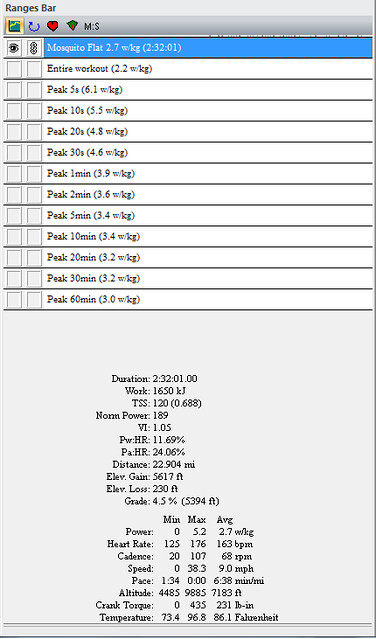
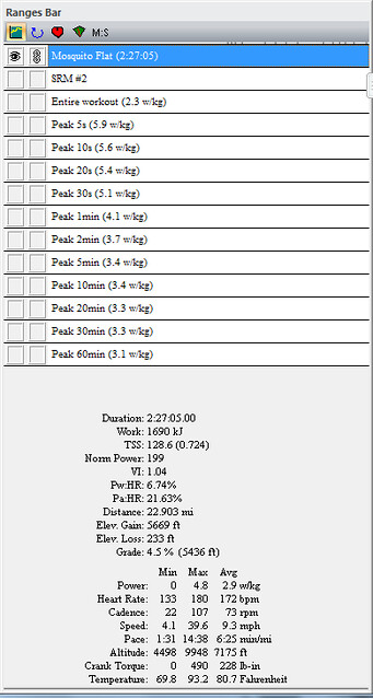
On Thursday 9/16 I climbed Mosquito Flat. I had a better day than I did two weeks ago on 9/2. Below you will see the graphs and data for both days. The first set is from 9/2 and the next set from 9/16.
Most notable improvements were:
5 minutes reduction in time (2:32 to 2:27)
10 watt increase in Normalized Power (189 watts to 199 watts)
.2 increase in w/kg (2.7 to 2.9 w/kg)
9 bpm increase in intensity (163 bpm to 172 bpm)
4% increase in Intensity Factor (68% to 72%)
5 rpm increase in Average Cadence (68 rpm to 73 rpm)
.3 mph increase in Average Speed (9.0 mph to 9.3 mph)
Crank Torque was reduced by 3 lb-in (which is also reflected in higher average cadence)
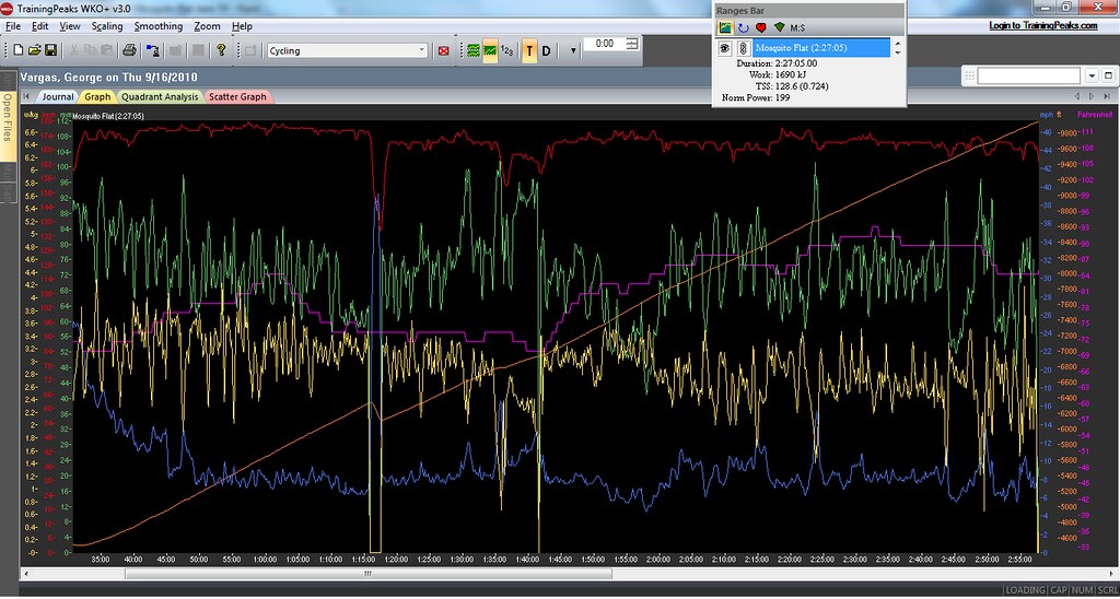
23 miles in a loooong way to climb and be able to sustain high power output– at least for this mere mortal. But I’m satisfied with the results and I feel my form continuing to build. I’m still undecided whether I will be riding Everest Challenge. In the days proceeding EC I will be at Interbike in Las Vegas and on my feet for many hours. I won’t have the luxury of traditional rest, hydration and home cooked meals. So we’ll see….
Thank you for reading my blog please pass it on to your friends.
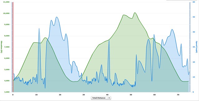
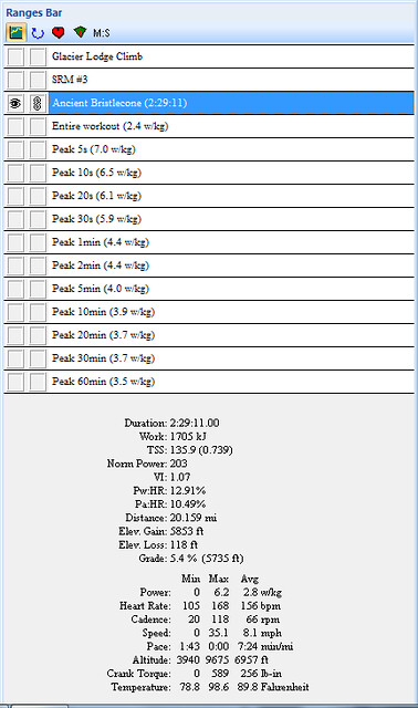
Glacier Lodge double peak and Ancient Bristlecone White Mountain double peak

Terrain map with Bishop as a reference Glacier Lodge West of Hwy 395 and Ancient Bristlecone White Mountain East of Hwy 395

12,000 feet of climbing in 52 miles (last 22 are descending to the car)
GARMIN PLAYER CAN BE FOUND HERE
Glacier Lodge Climb

Glacier Lodge Climb with Torque
Refer to this previous post for grade analysis of Glacier Lodge and Ancient Bristlecone/White Mountain Climbs

Middle section of Glacier Lodge hard to tell but over 9% avg for at least 7 of the 10 miles

Three deer on the road and bush near summit of Glacier Lodge
Summit of Glacier Lodge Climb (paved road) about 8,000 feet
 Glacier Lodge Summit 8,000 feet looking up at amazing scenery
Yes it was hot out in Big Pine!

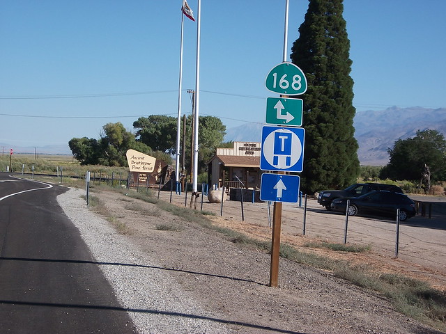

Ancient Bristlecone White Mountain Rd
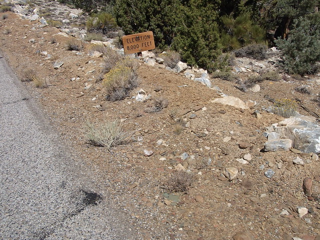
Easy to miss the elevation signs on the Ancient Bristlecone climb

Easy to miss the 9,000 feet sign too!

view from the vista point before the summit

View from the summit of White Mountain Rd
View from the summit of White Mountain Rd above 10,000 feet elevation
 Post on the completion of the 10 toughest climbs in California here is the list
Garmin Player Download
Most Difficult Climbs:
1) Onion Valley — DONE 6/10/10 !!
2) Horseshoe Meadows — DONE 6/10/10!!
3) White Mountain– DONE as part of Everest Challenge Stage Race
4) Sherman Pass– DONE 6/24/10!!
5) Whitney Portal — DONE 6/10/10!!
6) Mount Baldy– DONE- too many times to mention
7) Shirley Meadows– DONE 6/24/10!!
8) South Lake– DONE as part of Everest Challenge Stage Race
9) Mount Palomar– DONE 6/06/10!!
10) Mosquito Flat– DONE 09/02/10!!
Greatest Elevation Gained:
1) Horseshoe Meadows – 6,234 feet– DONE 6/10/10 !!
2) White Mountain – 6,204 feet
3) 190 – 6,199 feet
4) J21/245/180 – 5,750 feet
5) Mosquito Flat – 5,548 feet DONE 9/-2/10
6) Dantes View – 5,475 feet
7) South Lake – 5,445 feet
![]() Sherman Pass – 5,316 feet– DONE 6/24/10!!
Sherman Pass – 5,316 feet– DONE 6/24/10!!
9) Emigrant Pass – 5,309 feet
10) Onion Valley – 5,169 feet DONE 6/10/10!!
Highest Elevation Attained:
1) Mosquito Flat – 10,220 feet- DONE 9/02/10
2) White Mountain – 10,152 feet
3) Horseshoe Meadows – 10,034 feet DONE 6/10/10!!
4) Tioga Pass – 9,945 feet
5) South Lake – 9,852 feet
6) Sonora Pass – 9,624 feet
7) Kaiser Pass – 9,184 feet
![]() Onion Valley – 9,163 feet — DONE 6/10/10!!
Onion Valley – 9,163 feet — DONE 6/10/10!!
9) Lake Sabrina – 9,141 feet
10) Sherman Pass – 9,126 feet– DONE 6/24/10!!
Additionally, here is the list of the 10 toughest climbs in the US.
Below is a list of some of the top cycling climb bike rides that are listed in the bookBest Cycling Climbs In The US. The book lists the 100 toughest USA road bike climbs from 1 to 100.
I hadn’t climbed Mosquito Flat in a while mainly because I didn’t want to make the drive all the way to Bishop, CA. But with Everest Challenge coming at the end of the month, September 25-26, I thought it would be a good idea to climb it. Mosquito Flat is the highest elevation gained in California and the highest paved road in the Eastern Sierras.
“The road to Mosquito Flat at 10,250′ is the highest paved road in the Sierra Nevada. The climb is 22 miles, average grade is 5%. Maximum grade lower half is 9%, upper half is 11%. There is 280′ of descending along the way, bringing the total climbing to 6,048′.”
I had a rough day on the bike. I actually had wanted to climb not just Mosquito Flat but South Lake too. I was feeling like crap so I called it a day after just Mosquito Flat. Heck I only got 7,000 feet of gain in 65 miles— man I’m a slacker 😉
EPIC TRAINING TIP OF THE DAY
When you’re not feeling it “out there” then call it a day. Go home and take of yourself. Have a good meal, get some good rest and maybe even splurge on something– for me that’s ice cream. Trust me you’re not getting quality training if you’re just turning the pedals around. And trust me on this one too– you will come back the next day and ride like a rock star!


Above 9,000 feet Elevation this is my favorite section of the 20+ mile climb

The trailhead is just behind me at 10,200 feet!
At 9,000 feet Elevation looking up.

New guardrail going up on Lower Rock Creek Rd
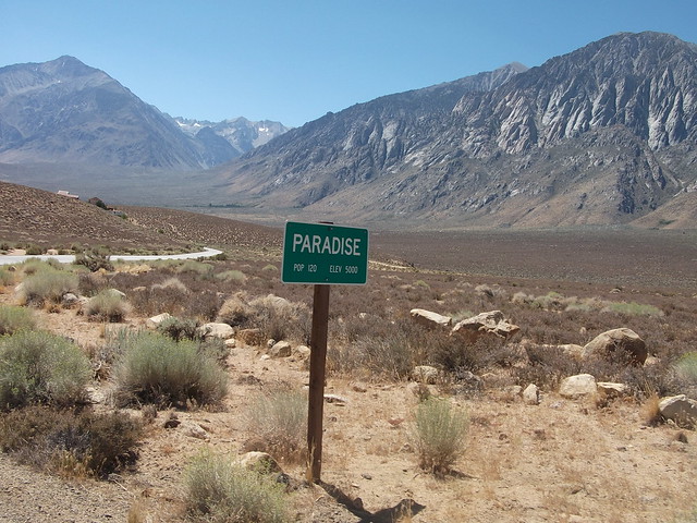
It's a climbers Paradise!
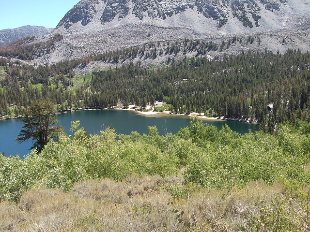
Rock Creek Lake
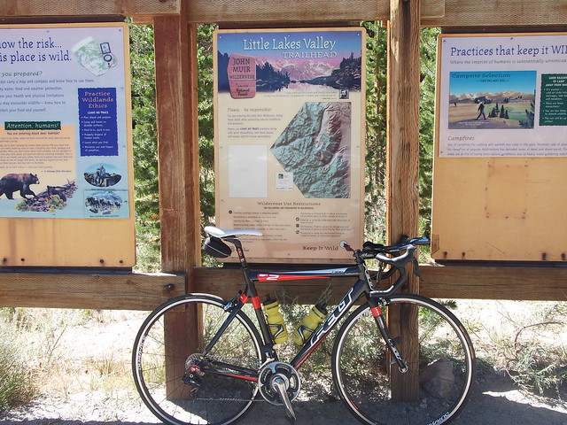
Trailhead at the end of Mosquito Flat climb

First post THE 10 TOUGHEST CLIMBS IN CALIFORNIA
Let’s begin by reviewing the list provided by John Sommerson, The complete guide to climbing (by bike) in California. John’s list was very interesting to me and I found it at just the right time. I was in a funk and hadn’t been riding. I had lost all motivation to go out and really train (read suffer). I thank John for his work on the California edition and his other books for inspiring me to get back out there and do what I love best about riding a bike — CLIMBING! Since my last post, two weeks ago about the 10 Toughest Climbs in California, I have been in contact with John. I asked him initially for clarification on start and finish of the climbs and then for advice. John has been very patient with me and gracious with his time. Thank you John — we’ll see you on the road. Here is the list:
Most Difficult Climbs:
1) Onion Valley — DONE 6/10/10 !!
2) Horseshoe Meadows — DONE 6/10/10!!
3) White Mountain— DONE as part of Everest Challenge Stage Race
4) Sherman Pass— DONE 6/24/10!!
5) Whitney Portal — DONE 6/10/10!!
6) Mount Baldy– DONE- too many times to mention
7) Shirley Meadows– DONE 6/24/10!!
8) South Lake— DONE as part of Everest Challenge Stage Race
9) Mount Palomar— DONE 6/06/10!!
10) Mosquito Flat— DONE as part of Everest Challenge Stage Race
Greatest Elevation Gained:
1) Horseshoe Meadows – 6,234 feet– DONE 6/10/10 !!
2) White Mountain – 6,204 feet
3) 190 – 6,199 feet
4) J21/245/180 – 5,750 feet
5) Mosquito Flat – 5,548 feet
6) Dantes View – 5,475 feet
7) South Lake – 5,445 feet
8) Sherman Pass – 5,316 feet– DONE 6/24/10!!
9) Emigrant Pass – 5,309 feet
10) Onion Valley – 5,169 feet DONE 6/10/10!!
Highest Elevation Attained:
1) Mosquito Flat – 10,220 feet
2) White Mountain – 10,152 feet
3) Horseshoe Meadows – 10,034 feet DONE 6/10/10!!
4) Tioga Pass – 9,945 feet
5) South Lake – 9,852 feet
6) Sonora Pass – 9,624 feet
7) Kaiser Pass – 9,184 feet
8) Onion Valley – 9,163 feet — DONE 6/10/10!!
9) Lake Sabrina – 9,141 feet
10) Sherman Pass – 9,126 feet– DONE 6/24/10!!
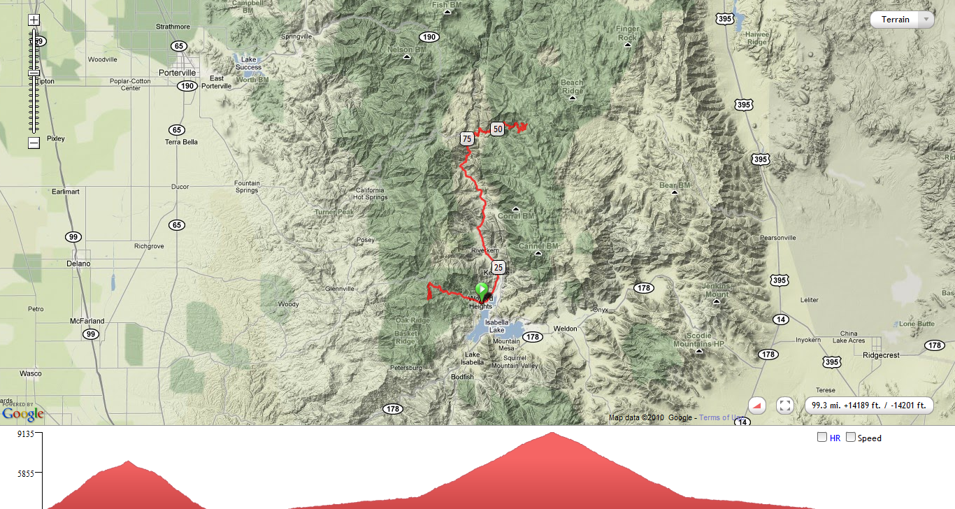
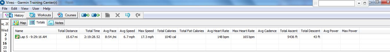
Today I climbed Shirley Meadows and Sherman Pass Road. I have now completed the Top 10 list. The challenge of completing the list kept me motivated during the weeks in between my trips. I planned, that is to say I daydreamed, and counted down the days until the next time I could escape to the mountains. I now need to find another challenge. In the meantime, let’s get on with today’s ride.
SHIRLEY MEADOWS
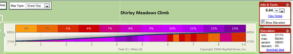
The scenic beauty of today’s ride was incredible. I parked at a convenience store in Wofford Heights. I asked the store employee if it was ok for me to leave my car there while I went for a bike ride and he mumbled what I think was “sure”. Little did he know my bike rides are centuries with 11,400 feet of gain. I was less than one block away from the start of the Shirley Meadows climb. It was very convenient in one respect but then I didn’t get a decent warm-up. As soon as you make the turn onto Hwy 155 BAM! you are greeted with a double-digit pitch that shocks your legs — even if you had a proper warm-up.

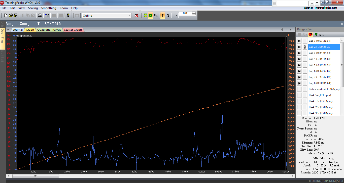
The climb is nothing but one steep ramp after another. This isn’t the type of climb where you sit down and settle-in to the climb. This is a stand and grind, sit and recover …rinse and repeat type of climb. I’m not kidding this is one steep climb but not all at once or in any semblance of a consistent grade like Onion Valley. I had to take a picture of one of the caution signs when I descending– 11% for 5 miles–no wonder I was suffering so bad. I would like to consider it a stair-step climb but that doesn’t describe it well enough either because there are only a couple of reliefs. The climb is only 10 miles but it takes your legs and trashes them in just that short of a distance.
My Felt F2 with Di2 was plenty stiff on the steep grades and the Di2 shifted FLAWLESSLY!!
What are the redeemable qualities for all this pain and suffering? The views! The views are spectacular. The road is in pretty good shape. So you can relax and look around when you’re not gripping your drop bars and pulling on them for dear life to turn the pedals over One.More.Time. I was riding my 2010 Felt F2 with Di2 with a 53/39 crankset and a 12/27 cassette because John had given me a heads-up about the steep grades on this climb. The 11/23 cassette I rode in the first edition of the 10 toughest climbs in California would have been a mistake today. The sharp hairpin turns lead you from one picturesque wooded area to another. And while the scenery is great on the way up, the descent is nothing short of breathtaking. It is straight out of a European tourist magazine. You descend with Lake Isabella down below and mountains and more mountains over-laying over each other as a backdrop. I imagined this is what it must look like when descending into Lake Como in Switzerland. My words just can’t do it justice– simply perfect postcard material at every turn!

Shirley Meadows Summit
Taken with my Blackberry phone–Like a bonehead I forgot my camera battery at home my Blackberry just didn’t capture it as I saw it live!
I refueled at my car and then started the 24ish miles to Sherman Pass Road. I didn’t realize what a slog it would be. There are pesky little rollers while you keep a 1-2% grade for 24 miles into a light headwind. But once again you are rewarded with spectacular views. You ride along the Kern river. The water is rushing and you see it crashing and splashing on the rocks. Then you look up and see cabins on the hillsides way off in the distance. I tried to imagine how beautiful this place would look like with snow. The views are postcard material yet again.
The Slog from Wofford Heights to Sherman Pass–1,500 feet of gain at .09% grade – in 24 miles
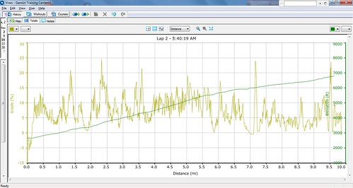
I was worried that I wasn’t going to have enough fluids for the 24 mile stretch AND the 15 mile Sherman Pass climb. But 19.5 miles from Wofford Heights there was a small store in Fairview with a spigot outside. I topped off and shortly thereafter I made the right turn onto Sherman Pass Road. Notice the climbing that begins at mile 20 and continues until you summit Sherman Pass Road at mile 60!!
SHERMAN PASS ROAD
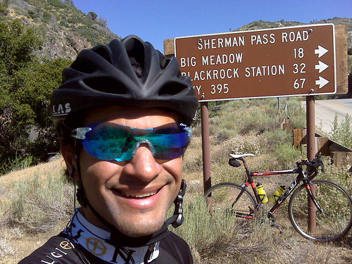
I didn’t find the climb difficult. The grades were consistent and the views were excellent. It was just LOONG! 15 plus miles. Funny story– about 1 mile into the climb I see a lot of cow patties. I said to myself where would the cows come from and why would they be hanging out on THIS road. About a mile later I see about 20 cows and calves grazing on the side of the road. When they spotted me they were startled but stayed put. As I got closer they started running up the mountain first at light trot then a full-on gallop. I kept thinking where the heck are they going? I didn’t see any place they could call home. But then, seemingly out of nowhere, there is a very narrow road and a gate. It was pretty comical seeing all the cows fighting to get through the gate.
The climb took me to 9200 feet and a clearing with an incredible vista. It was well worth all my effort. I didn’t like the descent only because the road was tore up in many places, there were sand patches and loose rock everywhere.
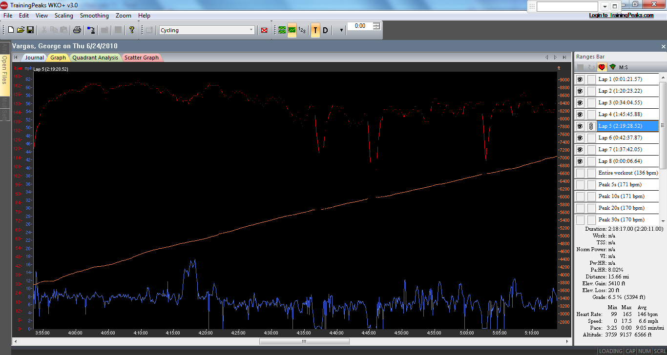

Sherman Pass Road- Obviously there weren’t 50% grades ignore the glitches

Sherman Pass Summit
The return leg back to Wofford Heights was really tough. Even though I was generally going downhill I was riding into a headwind. Yep pedaling downhill to maintain 15 mph. How do you like that? I eventually made it back but I was so frustrated. I had climbed that same section of road into a headwind and now I was descending it into a headwind.
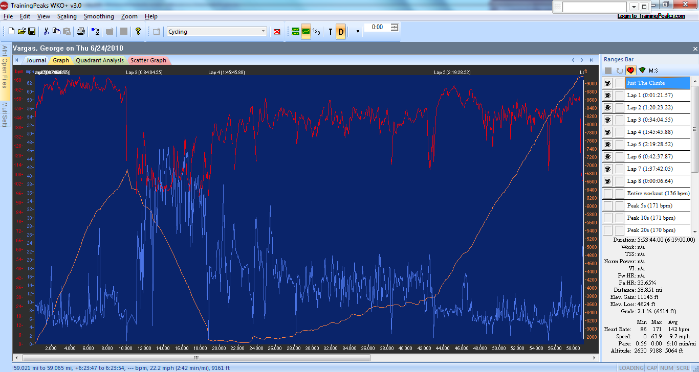
11k of climbing in just 58 miles
In the very near future I will post my opinion about each of the 10 climbs on this list. But for now I would like to say that today’s ride was the most scenic. When taking into consideration its the sheer beauty, its leg sapping climbs and the scarcity of cars and people on the road, I say the Shirley Meadows and Sherman Pass century I did today wins hands down!

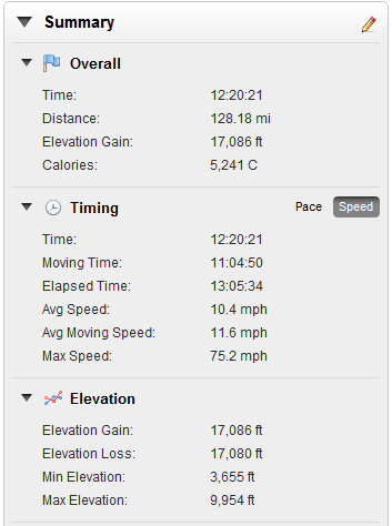
128 miles with 17,000 feet of climbing

5400 kjs – a good days work
UPDATE: THE TEN TOUGHEST CLIMBS CONTINUED…
CLICK HERE IS THE GARMIN PLAYER FOR THE RIDE
CLICK HERE FOR RIDE WITH GPS PLAYER
I came across the list below, California’s 10 toughest climbs, on Wednesday 6/09/10. I can’t remember what I was Googling at the time. But when I saw this list it really intrigued me. I thought wow this looks like a great “to-do” list to work off of. I asked a few friends for advice and planned a quick trip within a couple of hours.
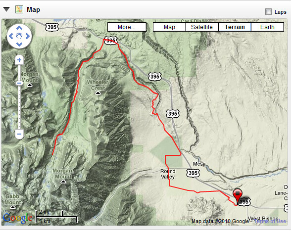
After consulting a map I found that quite a few climbs were concentrated in the Eastern Sierras. I also noticed that three climbs were in close proximity to each other. I got this crazy idea that I could do something REALLY Epic and do three of the climbs, Onion Valley, Horseshoe Meadows and Whitney Portal all from a “base camp” in Lone Pine. The ride turned out to be 128 miles with 17,000 feet of vertical gain. Subtract the 34 junk miles from Lone Pine to Independence and back and the final 11 mile descent off of the Whitney Portal and you have a 17,000 feet of climbing in 83 miles — far less than a century!! I personally don’t know anyone who has done all three climbs in one day!!
In his book, The Complete Guide to Climbing (by Bike) in California, John Summerson gives a great overview of the 100 hardest climbs in California.
He developed his own rating method, which is similar to the method used on this website, with additional adjustments for altitude, grade variability, and road surface.
Most Difficult Climbs:
1) Onion Valley — DONE 6/10/10 !!
2) Horseshoe Meadows — DONE 6/10/10!!
3) White Mountain
4) Sherman Pass
5) Whitney Portal — DONE 6/10/10!!
6) Mount Baldy
7) Shirley Meadows
8) South Lake
9) Mount Palomar DONE 6/06/10!!
10) Mosquito Flat
Greatest Elevation Gained:
1) Horseshoe Meadows – 6,234 feet– DONE 6/10/10 !!
2) White Mountain – 6,204 feet
3) 190 – 6,199 feet
4) J21/245/180 – 5,750 feet
5) Mosquito Flat – 5,548 feet
6) Dantes View – 5,475 feet
7) South Lake – 5,445 feet
8) Sherman Pass – 5,316 feet
9) Emigrant Pass – 5,309 feet
10) Onion Valley – 5,169 feet DONE 6/10/10!!
Highest Elevation Attained:
1) Mosquito Flat – 10,220 feet
2) White Mountain – 10,152 feet
3) Horseshoe Meadows – 10,034 feet DONE 6/10/10!!
4) Tioga Pass – 9,945 feet DONE 7/27/12!!
5) South Lake – 9,852 feet
6) Sonora Pass – 9,624 feet DONE 7/6/13!
7) Kaiser Pass – 9,184 feet
8) Onion Valley – 9,163 feet — DONE 6/10/10!!
9) Lake Sabrina – 9,141 feet
10) Sherman Pass – 9,126 feet
Additionally, here is the list of the 10 toughest climbs in the US.
Below is a list of some of the top cycling climb bike rides that are listed in the book Best Cycling Climbs In The US. The book lists the 100 toughest USA road bike climbs from 1 to 100.
ONION VALLEY

After work, I drove from Newport Beach to Lone Pine. I made a stop along the way to purchase a small point and shoot camera. I thought it was important to share my adventure properly. I hope you enjoy the pictures.
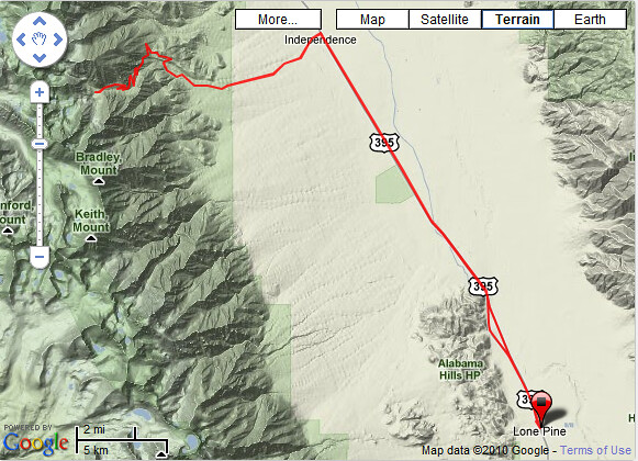
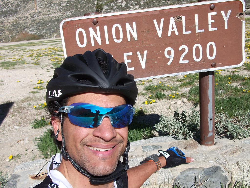
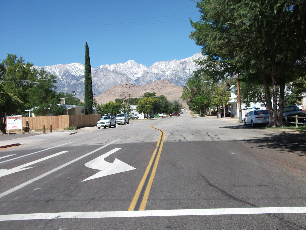
I arrived late in the evening. I stayed at the Whitney Portal Hostel (760) 876-0030. A nice clean and inexpensive place and I highly recommend it. On Thursday morning, I rolled out at at 5:30am. I rode the 16 miles to Independence for the first climb of the day — ONION VALLEY ROAD. My reasoning was if ONION VALLEY ROAD was considered the toughest climb in California it would be prudent to tackle it first, while the legs were fresh.
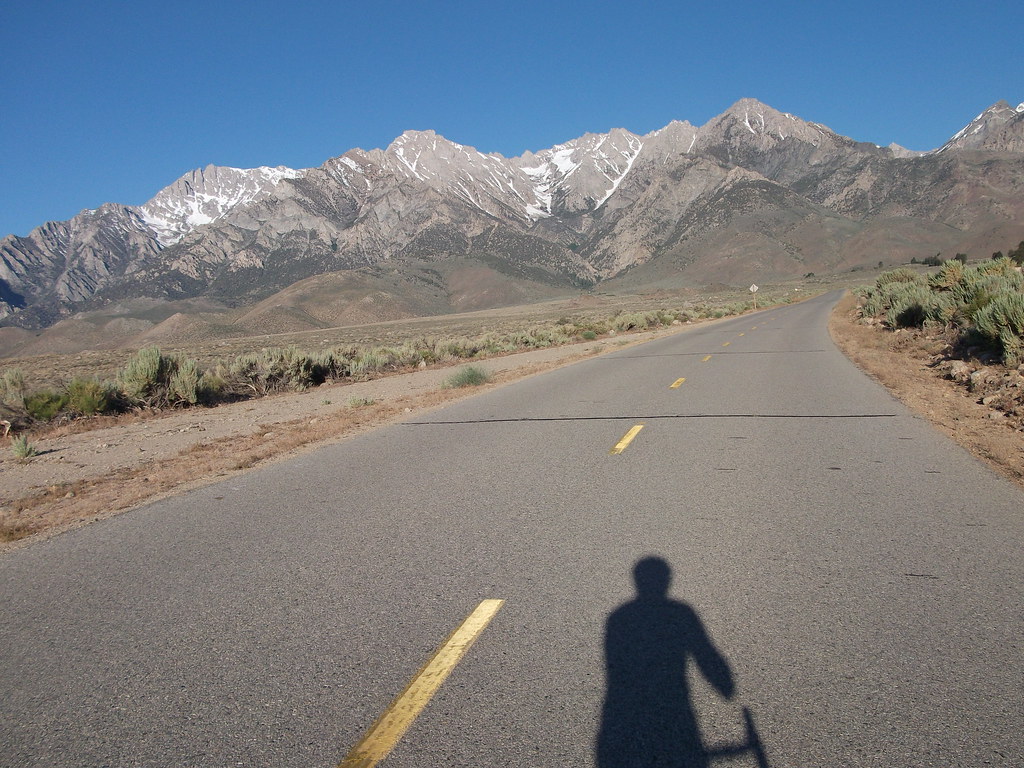

It can not be overstated, Onion Valley is one tough climb. Man when it ramps up and then stays at 8-9% for sustained sections– better said– miles and miles it really takes ganas to summit Onion Valley Road. I was riding Felicia – my 2010 Felt F2 with Di2. A fantastic riding bike and now I was putting her through a climbing camp. I had a standard 53/39 and an 11/23 cassette. I probably should have had at least an 11-25 cassette. Later in the day I would regret the 11/23. As I mentioned before, I left straight from work and didn’t want to stop by the house. This was a spontaneous trip. I had my bike with me and a couple of cycling kits in my “race bag”. I figured I would buy what I needed along the way. Unfortunately, I wasn’t prepared for the steep grades dished out by Onion Valley Road. I had been riding mostly flatter training rides in the Orange County area hence my cassette was an only an 11-23.
I really enjoyed the climb even with all the steep grades. It was early in the morning and there were no cars on the road. I actually can’t remember seeing a car for the full 26 mile round trip up and down Onion Valley Road.
Nice Smith Pivlock 90’s- Thank you Smith Optics
Felicia- My Felt F2 with Di2 which performed FLAWLESSLY!!
The descent was very sketchy. The winds were swirling on the climb up, which was manageable at slower speeds. But on the descent, I would get up to 50 mph and bank into the corner and BAM! get hit with a massive gust of wind and be blown off my line completely. After three of these scared poopless moments I decided to slow down and take the corners more conservatively. The winds were so unpredictable and so strong I was surprised that even with my low profile training wheels that I was getting tossed around so much. When I reached the straighter sections of the descent I let her fly.
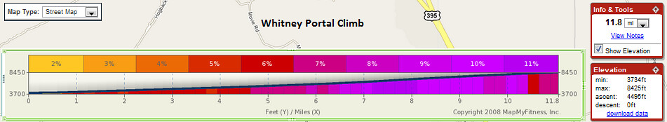
The last 10 miles of this 12.5-mile ascent are the steepest stretch of that length in the country–and also higher than 5,000 feet, a combination that unquestionably makes it the most difficult. The first 2.5 miles are a great warm-up. Like most Eastern Sierra climbs, the road sneakily gets steeper as you ascend, then the switchbacks begin and you’re in no-man’s land: too far up to see the start, too far down to see the finish. After you clear the Sierra foothills, the twisting road eases its slope then kicks into an alpine climb along a narrow road between soaring rock walls, with the massive Owens Valley visible behind you. You hear but cannot see a rushing creek. Close to the top, an elegant S-curve funnels you into an alpine bowl, then the climb ends soon after. Longer than Alpe d’Huez and steeper than the Galibier and Tourmalet, the last 10 miles of Onion Valley are legendary. Get There: From Independence, turn west on Market Street. The road becomes Onion Valley Road; the climb starts at the cattle guard.
HORSESHOE MEADOWS

After my descent of Onion Valley Road I had to ride the 16 miles back to Lone Pine. It was generally downhill and I had a slight tailwind. I refueled at my “base camp” Whitney Portal Hostel. I then headed up for my second major climb of the day. The second toughest climb in California — HORSESHOE MEADOWS.
 There is one thing I should mention about my return leg to Lone Pine. The 395 is under construction. There was only one lane in certain sections. I had to take the lane and I think some motorists were upset but there was no shoulder as you can see from the photo above. As I stated before it was generally downhill 1% grade and a little tailwind. So I Time Trialed the sections with no shoulder above 300 watts going 30 +mph. 😀

Three miles into the Whitney Portal climb you see the turn off for Horseshoe Meadows
Ok back to the Horseshoe Meadows climb -this is one beast of a climb. 20+ miles and over 6,000 feet of gain!! And it’s not just the vertical gain, but the grade just kicks up and is unrelenting. When you first see the switchbacks they are awe inspiring. They are so far off in the distance and yet they still look massive. See below.
The HORSESHOE MEADOWS climb was difficult because there weren’t any signs telling me what was up ahead. Even when there was a sign it didn’t state the mileage to the campgrounds or to the summit. I am a data geek and sometimes that can be my downfall. I like to know the stats of a climb and keep them in mind as I ascend. I like to know, for example, 10 mile climb 3,000 feet of gain. My Furnace Creek 508 crews have always been made well aware of my need for climb data– ACCURATE climb data. All three of the climbs I did yesterday were new to me. And while that was part of the allure it was also different for me to not know what to expect.

Much needed shade tree
Half way up the mountain, the perfect climbing weather I had enjoyed earlier in the day was turning out to be a scorcher– over 95F! I was only carrying three bottles– two on the bike and one in my jersey pocket. I was conserving my fluids for the 20+ mile climb. Now a little insight into the way my mind works– I’m too hard on myself and I always think a climb should be done in one shot– that means no stopping. And that rule applies whether it’s 2 miles or 22 miles. But I was starting to feel the cumulative effects of being on the second major climb and only having had 4 bottles in the last three hours. I pulled over and took 5 minutes to cool down. The shade felt great and although I wanted and needed to stay longer I had to keep moving. There is always this little voice that says “GET BACK ON THE BIKE!” When I reached the summit I couldn’t find an elevation sign so here is what I have for proof that I was there 😉 You have to be prepared to be on a climb for at least 2 hours (if you can climb at 10 mph which most of us can’t) and then descend at least another 30 minutes with fluids and/or solid fuels for a round trip of at least 2.5 – 3 hours of very intense climbing and descending in the heat of June!
ELEVATION 10,000 FEET!

HORSESHOE MEADOWS, the second toughest climb in California, done!! I front flatted on a sharp corner going about 30 mph. I kept the bike under control and came to a stop. Whew!! I then descended the rest of the way back to the Whitney Portal Hostel to refuel.
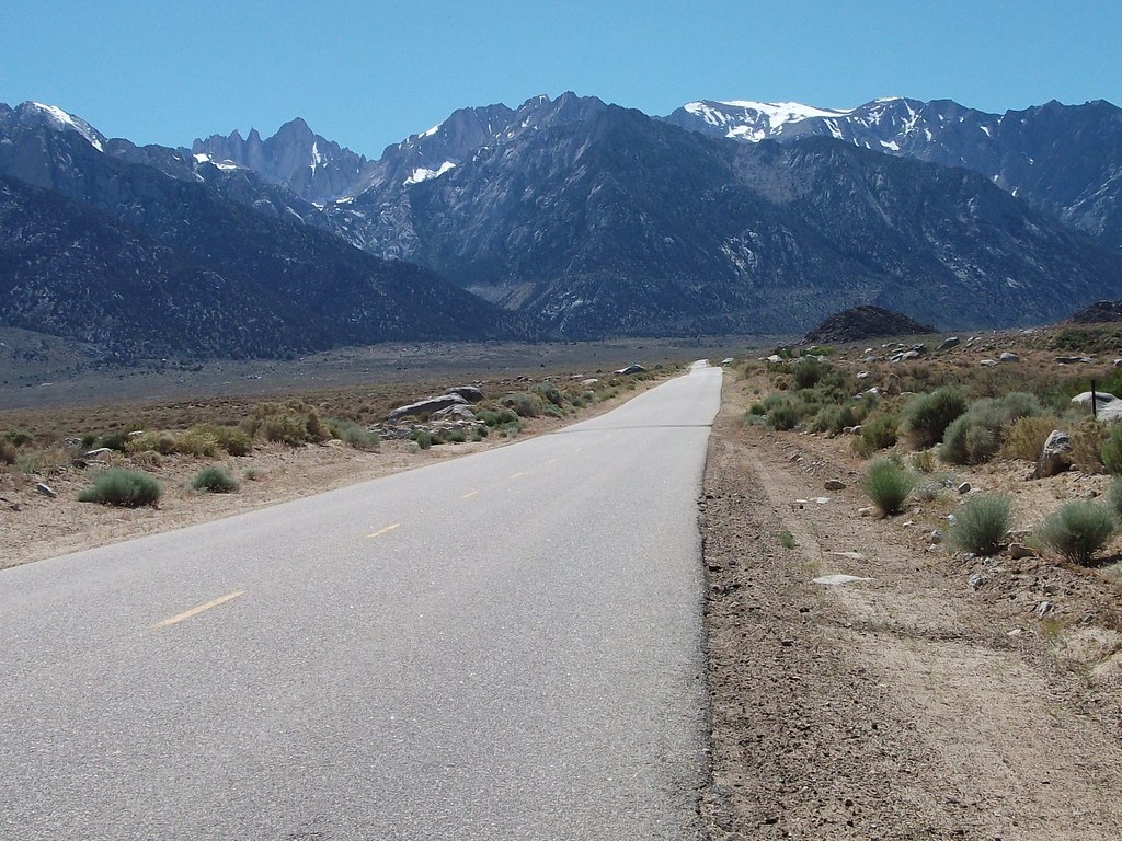
WHITNEY PORTAL
A description of the Whitney Portal-
Stage 10 (Monday July 14) Pau – Hautacam 154 km
After L’Alpe d’Huez the Col du Toumalet may be cycling’s most famous climb and the big test of stage 10. California’s Whitney Portal is very similar although perhaps even a bit more difficult and spectacular; a rarity in the world of mountain cycling.
Whitney Portal
Total elevation – 4,580 ft Length – 11.3 miles
Average Grade – 7.7% (13%) Rating – 3.98 (hors)
 Whitney Portal is a great and difficult climb out of the high desert up towards Mount Whitney, the highest mountain in the lower 48. Like most eastern Sierra ascents this one starts out tame and ends up tough. The grade generally increases as you climb so that a five mile stretch in the 2nd half averages 9%. The hill lets up just before the finish at Whitney Portal and a parking/hiking area (trailhead to Mt. Whitney). Whitney Portal is also very similar to the famed French climb of the Madeleine, a monster frequently used in major cycling classics including regular appearances in the Tour de France
(closed in winter – Inyo National Forest – 760 876-6222).
My last climb of the day was Whitney Portal. I began the climb about 3pm. Needless to say it was the hottest part of the day. I could’ve and should’ve spent more time in the air conditioning of the Whitney Portal Hostel. It would have helped get my core temperature down before starting the third major climb of the day. But I was determined to get out there and get it done. According to John Summerson’s book, Whitney Portal is the 5th Toughest Climb in California.
I really struggled on this climb. The 53/39 and 11/23 cassette were now a detriment to me getting up the “hill”. Whitney Portal is really steep for the last 5.5 miles, averaging 9% grade. I had to pull over four times finding small bushes and trying to put my head in the meager shade provided by them. There weren’t any trees on the Whitney Portal climb until the higher elevations. As a matter of fact, all three of the climbs were very exposed. There isn’t shade anywhere to be found.
After suffering on the lower slopes I got onto the switchbacks was now in the shade. On the lower slopes I was heading straight into the sun. But on the switchbacks the mountain was blocking the sun and providing much needed shade. My legs were wrecked, the fatigue of the 15,000 feet of gain so far, was making itself very apparent that maintaining even 5 mph was a struggle. I made it to the top but it wasn’t pretty nor was I as swift as I had hoped but I “got ‘er done”! I looked at my Garmin 310XT –17,000 feet of gain for the day wow!!
Look for the switchbacks on Whitney

Tackling all three of these massive climbs in one day was my goal because of the close proximity of two of them to each other – Whitney Portal and Horseshoe Meadows. But honestly, it was a bit too much. It was a huge psychological battle to complete my final climb of Whitney Portal. It was hot, my legs were shot and I was nauseous. I think I was affected by the altitude on the Horseshoe Meadows climb. Additionally, I know I was beyond behind on calories and hydration. It’s just too hot to be unsupported for that long.
What I wasn’t given in genetics for climbing ability I was given in just plain stubbornness. I can tolerate an awful lot of pain and I strongly believe that I can tolerate more pain than the next guy. I also know my body pretty well. After seven years of Ultras and training for them I have learned how far I can push my body, in particular because I train alone. I know just the precise time to take that “5 minutes” off the bike so that I can continue without the infamous meltdown. When attempting this ride you should know that aside from refueling at Lone Pine there isn’t anywhere else to refuel. I’m glad I did the three climbs but I don’t think I will be doing the three climbs in one day again…well at least anytime soon.
I like the order in which I did the climbs- Onion Valley then Horseshoe Meadows and Whitney Portal last. For me knowing that I was saving the “shortest climb” for last was comforting. You know your perspective is skewed when you think an 11 mile climb is short 😉 You rationalize things like this “Ok all I have to do is get to the top of this (Horseshoe Meadows) and then descend and do the short climb up to Whitney Portal.” When climbing a 20+ mile climb an 11 mile climb IS shorter! But sometimes shorter doesn’t mean easier and shorter many times means STEEPER!
My recommendation for something epic enough would be to do Horseshoe Meadows and Whitney Portal in one day! The grades are so steep and they go on for sustained sections that you don’t need to throw in the third climb. But if you do want a “three bagger” then do the Onion Valley Road climb first like I did. If you don’t mind driving the out and back, you could use that time to recover and refuel instead of riding that section and adding to the cumulative effect that comes from riding an extra 34 miles. But if you’re like me getting in a car in the middle of a ride is ludicrous.
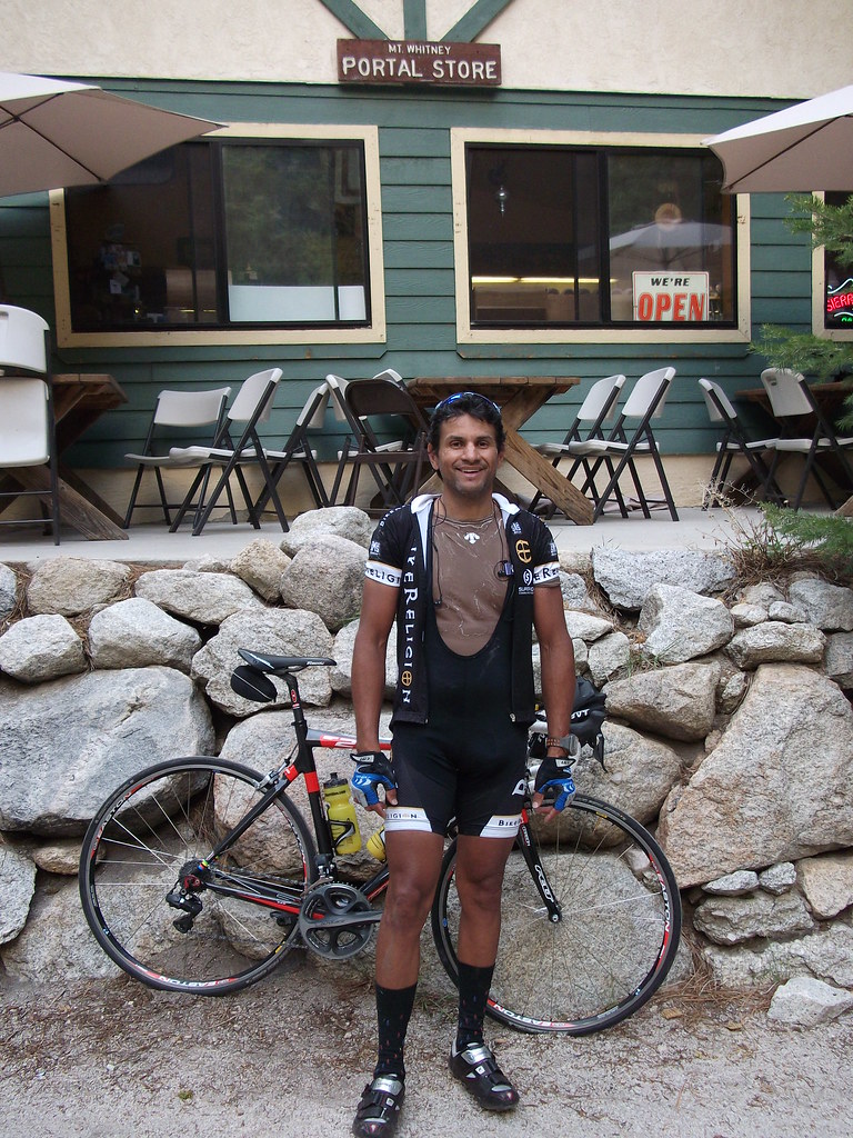
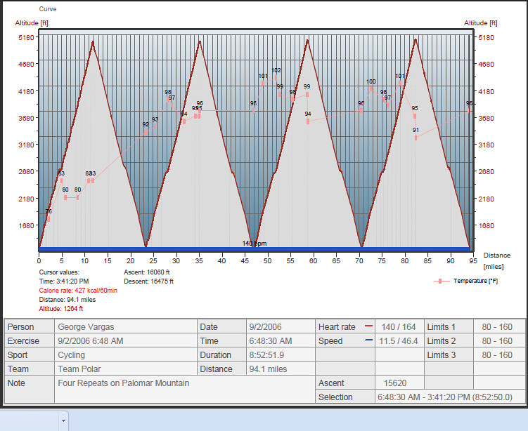
As far as the other climbs on the list, many of them I have done numerous times. For example, Mount Palomar used to be a weekly training ride for me and here is a blog entry from last Sunday. I have also done four repeats on Palomar Mountain in one day see below. So actually within the last five days I have done four of the toughest climbs in California 😉
Number 3 on the list, White Mountain, is part of the Everest Challenge, a race I have completed on two separate occasions. Actually, Everest Challenge helps take care of a couple more climbs on Mr Sommerson’s list of the 10 toughest climbs in California. As part of Everest Challenge, I have also completed Number 8 South Lake and Number 10 Mosquito Flat.
At Number 6, Mount Baldy, is a local favorite and I have been known to do repeats on that mountain as well. The last four miles to the ski lifts are very steep at over 10% average.
The only two climbs left to complete Mr Sommerson’s list are Sherman Pass and Shirley Meadows. Sherman Pass I had heard of but Shirley Meadows was a surprise. I hadn’t heard of it but there are so many great climbs in California how can one person know them all? I will make another trip out here and the list will be complete.
I now have a challenge for you. Why not make 2010 the year you complete the 10 toughest climbs in California? I will call it the “10 in 10 Challenge”. Bookmark this post and as you complete your 10 ascents, or some portion of it, and comment on my blog. I want to motivate YOU to do something EPIC this year!
I have to thank INFINIT NUTRITION for keeping me fueled during this ride. Please give them a try — customize your nutrition based on your race or training needs. When you do use discount code “vireo” and receive 10% off your order!!
All for now and thank you for reading my blog.
